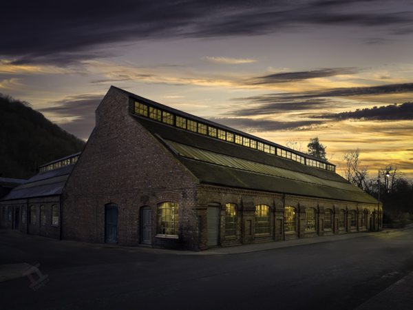
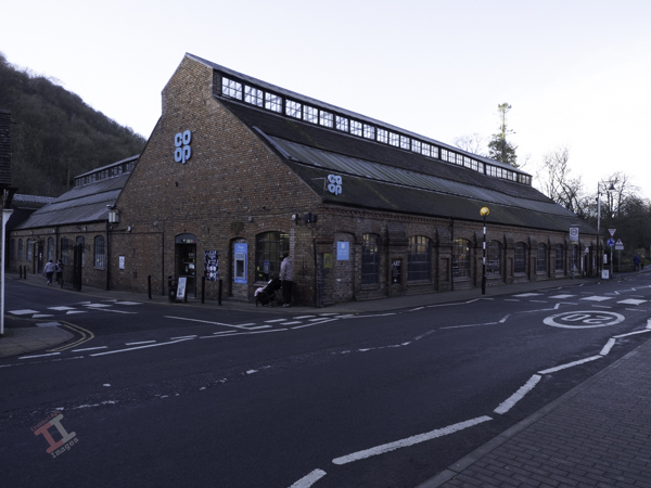
I make no excuses when I state that this is a heavily-edited image of the Merrythought teddy-bear factory in Dale End, Ironbridge – now more commonly known as the Co-Op.
Taking a memorable photograph of this building now is virtually impossible due to the multitude of signs and road markings that adorn the exterior. I started my post-processing by removing some of the signage and people, but as I progressed, it seemed that the final image was going to work far better if it became more of a re-creation of the building in its heyday.
This took some more careful editing, including replacing some of the doors that were originally there. Finally, I replaced the boring, plain Winter sky with a golden sunset and made a day-to-night conversion, which included lighting the interior of the building.
Some may say that this is taking editing too far – but I think that it makes a nice image of an industrial building that is otherwise uninspiring. What do you think?
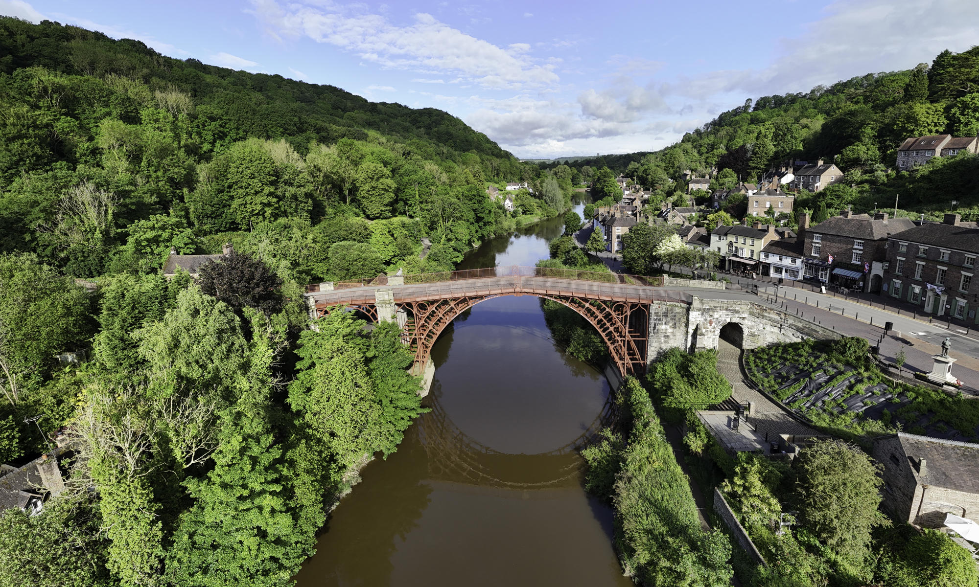
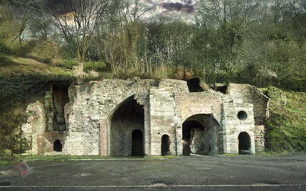
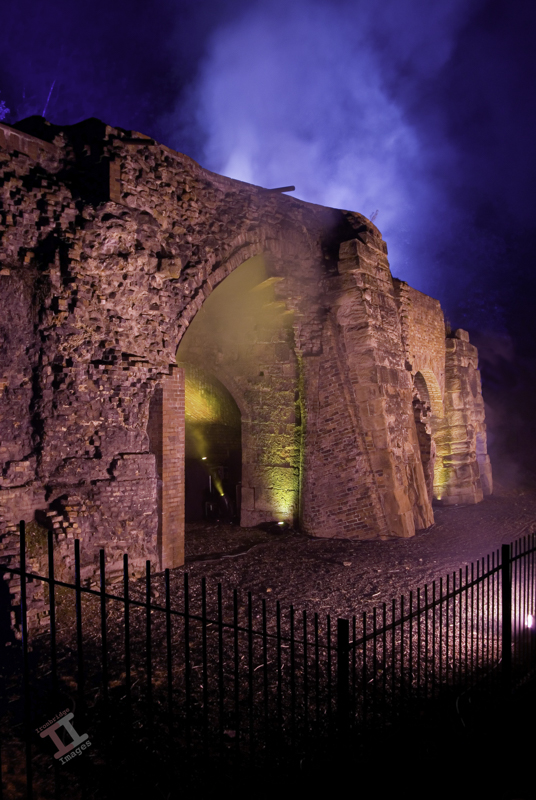
The Bedlam Furnaces are situated a short distance from Ironbridge Town, downstream of the Iron Bridge. The furnace ruins have been disfigured by a large metal canopy installed by Historic England to protect it, and so I have ‘recreated’ how it used to look in the image below.
It is believed that these furnaces were given the name by a couple of artists in the early 1800’s who thought that the site resembled a lunatic asylum (presumably because it appeared so chaotic and dangerous). The furnaces were built in 1756 and some believe that parts of the Iron Bridge were cast here, due to their close proximity to the river crossing site compared to the furnaces at Coalbrookdale.
The term “bedlam” originates from the name of a hospital in London, “Saint Mary of Bethlehem,” which was devoted to treating the mentally ill in the 1400s. Over time, the pronunciation of “Bethlehem” morphed into “bedlam” and the term came to be applied to any situation where pandemonium prevails.
Behind the furnaces is an area which some (older) locals will recall used to be the site of a large natural gas tank that supplied the town with its gas, for lighting, cooking and heating, before the days of ‘mains’ gas. It was later landscaped into ‘Galleon park’, so called because it had a giant wooden ship as a play area. Sadly, this has now rotted away and the park is barely maintained.
Bedlam Furnaces, Ironbridge Gorge
Back in September 2008, there was a ‘festival of light’ at Ironbridge, where various landmarks were illuminated with a light show – including Bedlam Furnaces.
Here is one of my shots from the evening – it created an ethereal glow over the ruins.
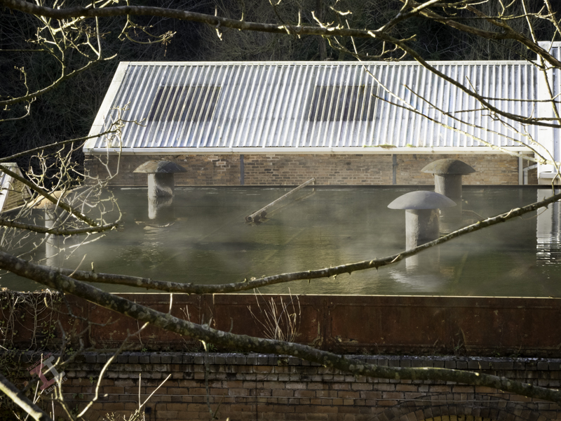
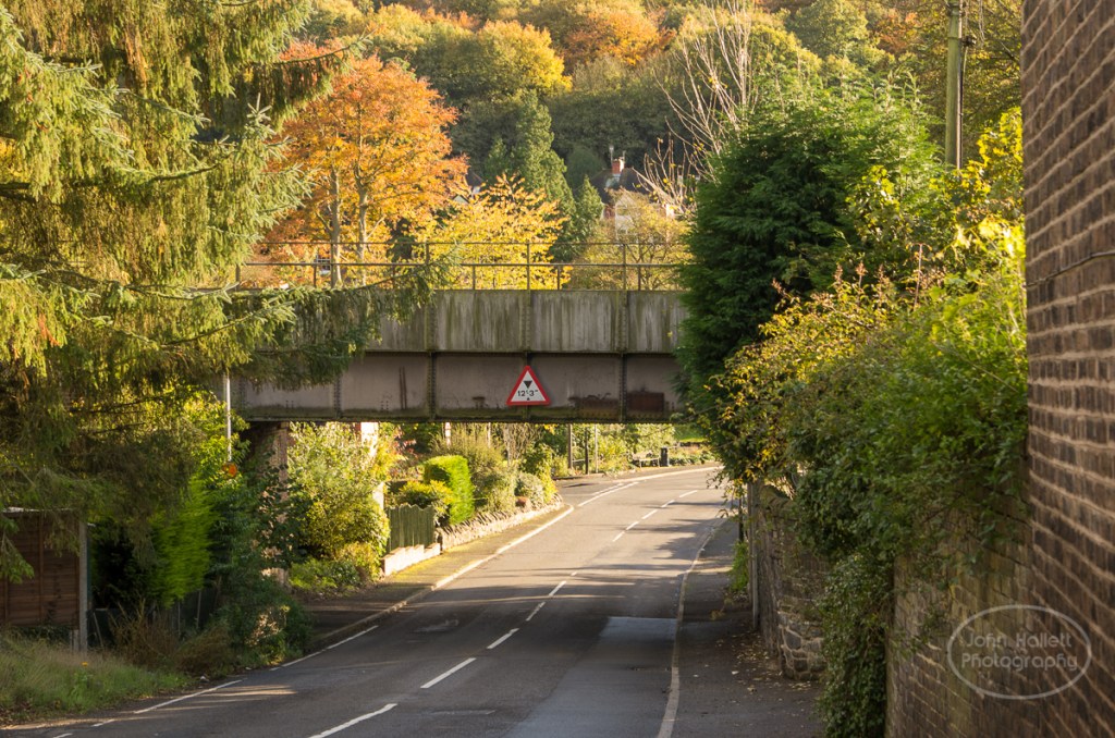
If you walk down Wellington Road in Coalbrookdale, just past the Coalbrookdale Inn and the junction with Church Hill, you can see an industrial building with a flat roof and (what appears to be) four metal mushrooms growing out of the top.
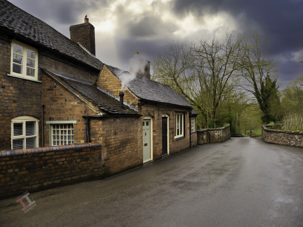
This building was the compressor house for the Coalbrookdale Works. The compressors were water-cooled (compressing air generates a huge amount of heat) and the heated water was pumped through the mushroom domes onto the flat roof to allow it to naturally cool, before draining back down to the compressors below to repeat the cycle. I can vividly remember as a child, when visiting my Aunty who lived nearby, passing by this building and seeing the hot water gushing from the domes, with plumes of steam rising from the rooftop as it cooled.
The compressor house is included with the Erecting Shop and Assembly Shop as a listed building. These buildings date from 1879, although it is likely that the compressor house was a later addition. Recently, there was a planning application to modify the building for residential use (as part of a much larger plan to redevelop the Coalbrookdale Works site) which would have meant the loss of the rooftop water tank, and hence any indication of its past function. Fortunately, on appeal, the Secretary of State’s inspectorate made it quite clear that this was not acceptable and so, for the time being, the compressor house remains.
It may be coincidental, but Heras security fencing and unmanaged undergrowth now mask the view of the compressor house from the road. I managed to get this shot through the fencing and, with a bit of post-processing, cleared the view. I have also added a bit of steam in a nod towards my childhood memory.
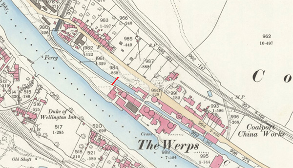
This narrow cast-iron footbridge crosses the Shropshire Canal close to the Coalport China Works.
Although it looks original, it is actually an impostor, and was brought in from the Shrewsbury Canal at Long Lane near Wellington when this section of the Shropshire Canal was restored in the 1970’s. When you think about it, this canal was built for an industrial purpose – to transfer tub boats of coal on the Transhipment Interchange from the canal, to the river – and the last thing that the barge haulers would need would be another bridge crossing over the canal, limiting the height of the load on the tub boat and snagging the rope used to pull it. There was a bridge, but this was at the entrance to the Coalport China Works.
A little bridge
Here is an Ordnance Survey map from 1881 and I have placed a red line in the approximate position of this impostor bridge. As a point of interest, prior to the 1890s the buildings on Ordnance Survey maps were coloured; carmine (pink) for buildings of brick or stone, and grey for buildings of wood or metal. The colour was applied by hand, either by boys or women, paid on a piece-work basis.
This narrow road bridge crosses the Hay Inline Plane at Coalport. Most people probably don’t even give it a thought, apart from when they have to give way to oncoming traffic, but the bridge dates from around 1792, the same time that the Hay Incline Plane was built, due to the bridge crossing it, at the point that it meets the Shropshire Canal at its low level, adjacent to the river Severn.
The bridge is a Grade II Listed Building and the small building to the left must, judging by its orientation and layout, have originally been a toll house. For many years it was the village shop but more recently has been a barbers, and now a hair-dressing salon.
Bridge over the Hay Incline Plane
In 1801, the chain pulling an empty tub boat and cradle up the incline snapped, sending both hurtling into the canal just below the bridge, destroying another three tub boats in the canal. Shortly afterwards, wire ropes replaced the chains because these were less likely to become worn and snap.
The last recorded use of the incline plane was in 1894 and it formally closed in 1907. The original tracks were removed and the incline became overgrown – the tracks laid on the incline today are merely a re-creation of what they were – in reality, the centre of each track would have rollers to support the wire ropes pulling the tub boat and cradle up the incline.
I have looked at the statistics for my blog for 2024 to see what I can learn from them and how I can improve in 2025. Here are my findings:
Summary:
In 2024, I wrote 84 blog posts, totalling 20,000 words. This resulted in 2,600 visitors (up 170% from the previous year) and 5,600 page views (up 131%).
The yearly statistics are interesting for me, in that I ‘retired’ from motorsport photography at the end of 2022, and yet visitors and views now seem to be on the increase, contrary to what I was expecting when taking into account the sheer quantity of motorsport images that I used to take. I suppose it proves the old adage that “quality is better than quantity”.
Set back from the road, on the Wharfage at Ironbridge, are these three arches which, from studying a map from 1882, are most likely to be lime kilns.
Limestone was commonly used in iron smelting as a flux to remove impurities. However, only the highest quality limestone was used for this purpose and the lower quality was burned in kilns, such as these, to produce quicklime which was used in building mortar and lime wash. The kilns operated at 900 degrees Centigrade and would have filled the air with noxious fumes that would have hung over the river, making it an unpleasant place to be.
In this Secret Ironbridge blog post, we’ll venture down on to the River Severn.
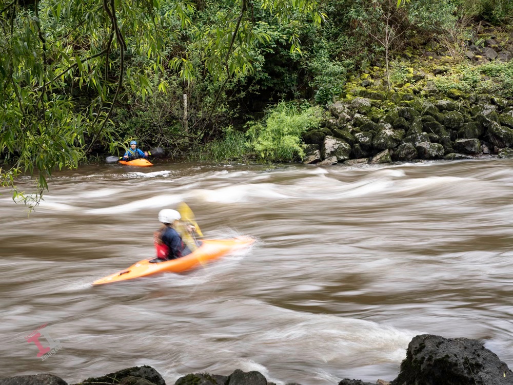
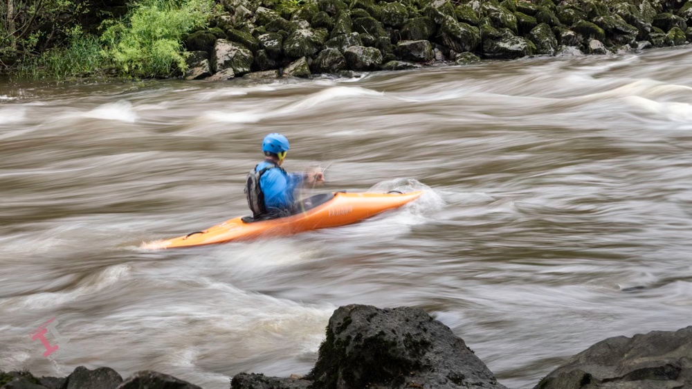
The river Severn is the longest river in Britain, and it has flowed down the Ironbridge Gorge since it was formed during the last ice age. Within the Ironbridge Gorge is a stretch of river, well-known and popular with kayakers: Jackfield Rapids.
The rapids are reported to have eroded over the years and are not as severe as they were. The difficulty changes depending on the river level, with it getting harder at higher levels (presumably because the flow of water is greater).
Although these rapids are a natural phenomenon due to ground movement, there is anecdotal evidence that they have been enhanced over the years to make them more challenging to canoeists and kayakers.
This was taken with an internal neutral Density (ND) filter in my Olympus camera, negating the need for filters added to the lens to achieve the silky flowing water.
Which leads to a question; at what point did the term ‘kayak’ replace ‘canoe’ in the UK? When I was a mere lad, these small, usually one-man, self-powered boats were always called ‘canoes’. Apparently, there is a difference: a ‘canoe’ usually has an open deck, can be used seated or kneeling, and has a single-ended paddle. A ‘kayak’ has a closed deck, a seated position and a two-ended paddle. Now I know!
We have already seen the London & North Western Railway running into Coalport (East) station and the Great Western Railway running through Coalport (West) station to Ironbridge and Broseley Station.
Here, we come across the Severn Valley Railway, which formed part of the line between Wellington and Craven Arms and was built (in stages) between 1857 and 1863. It had to cross the River Severn and did so via the Albert Edward bridge.
Albert Edward bridge (taken in 2013)
The bridge is named after Queen Victoria’s eldest son (who later became Edward VII). It was designed by Sir John Fowler and cast at the Coalbrookdale Foundries in 1863. It is considered one of the last major cast iron railway bridges built. Unlike the other two railway lines in the Gorge, this one continued to operate until 2015 – carrying coal wagons to the Ironbridge Power Station.
The bridge today – being reclaimed by nature
The centre of the span of the bridge denotes the boundary between Telford & Wrekin Council and Shropshire Council, and it is designated a Grade II Listed building, each Council claiming half.
Building bridges:
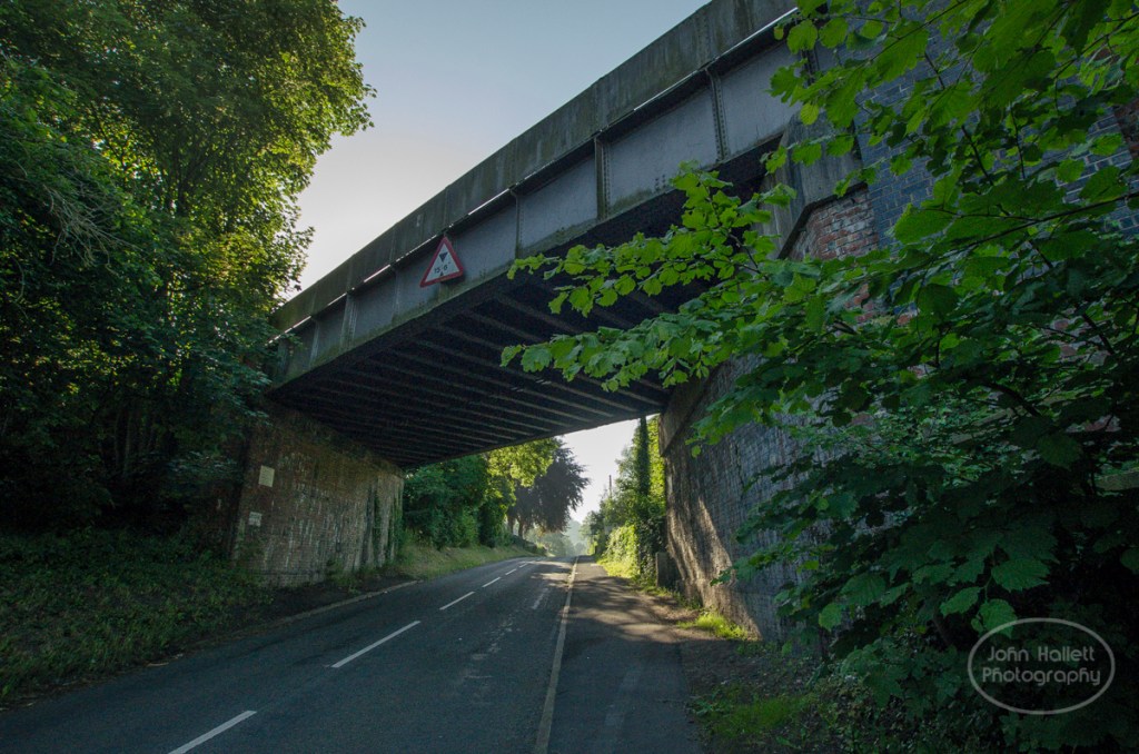
You may ask why the railway bridges in the south and east of the Ironbridge Gorge were built out of attractive brick and stone, whilst the railway bridges in the west are generally utilitarian metal girders. The answer is quite simple: building the section of the railway line between Horsehay and Coalbrookdale was a costly exercise, and metal bridges were cheaper and better advertisements for the Coalbrookdale Company than masonry ones.
As the Great Western Railway passes Bowers Yard and heads towards the site of the old power station, it runs very close to the River Severn, and so the Victorian engineers decided that the best solution was to build a viaduct parallel with the river.
A viaduct is a specific type of bridge that consists of a series of arches, piers or columns supporting a long elevated railway or road, typically connecting two points of roughly equal elevation. Contrary to popular belief, if doesn’t necessarily have to be crossing over water. Such is the case here; the viaduct merely elevates the railway above the banks of the river, it doesn’t actually cross it at any point.
It is easy to miss another great feat of Victorian engineering; although you can still traverse the viaduct by foot, the base of it has become surrounded by trees, and ivy clings to the brickwork. Fortunately, my drone was able to fly over the river and catch some shots that otherwise would remain unseen.
There has been some recognition of the viaduct and a lot of ivy has been removed since my shot taken in 2013:
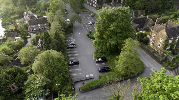
If you visit Ironbridge by car, you may well follow the signs to Ironbridge Central car park and wonder why it has that name, given that it really isn’t ‘central’ to anything.
This was a name dreamt up by the illustrious Telford & Wrekin Council, but the car park is still known by locals as ‘Station Yard car park’. Why? Because it is on the site of a long-gone railway station on the Great Western Railway (GWR) line.
This entire car park was once a bustling railway station
It was named Broseley and Iron Bridge station on the basis that, at the time it was built in 1862, the majority of the stations passengers came from nearby Broseley, which had a much larger population than around the bridge. During its life the name changed several times (perhaps by grammatical pedants) and was called:
Ironbridge and Broseley
Iron Bridge and Broseley
Iron-Bridge and Broseley
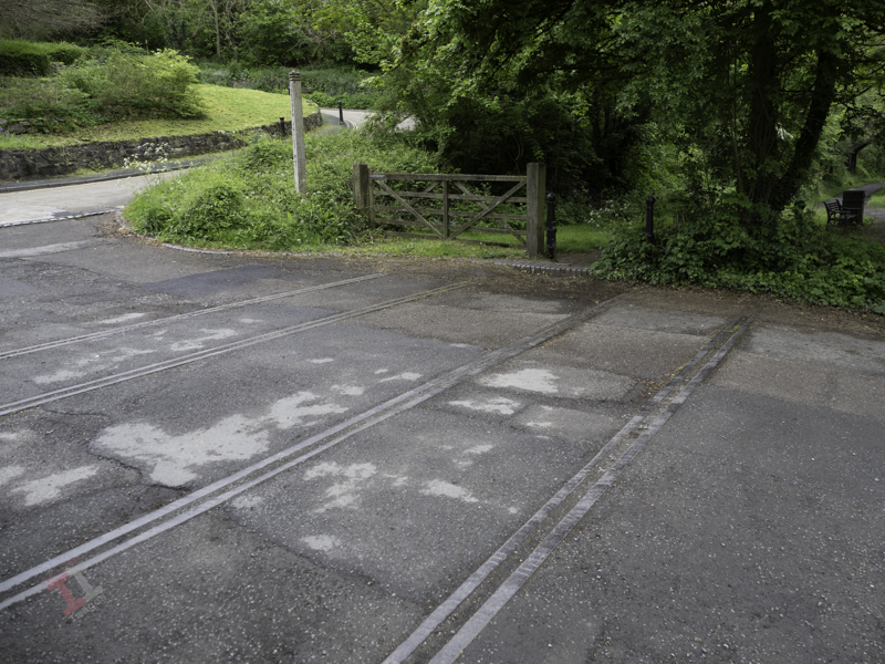
Apart from the single-storey station building adjacent to the bridge, there were two platforms, a a lattice footbridge connecting them, a substantial signal box, numerous sidings and a goods shed. There was also a level crossing (the remains of the track can still be seen) controlling traffic crossing the bridge.
The only remains – railway tracks crossing the bridge approach
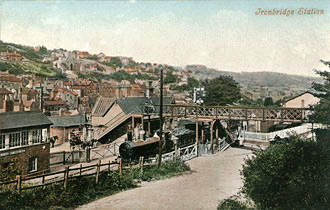
A popular postcard of the time shows the signal box, footbridge and level crossing gates.
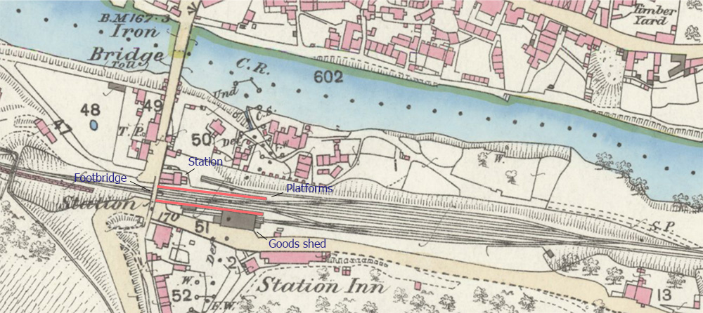
A map of 1883 shows that, just 20 years after it opened, the station yard was a busy place and subsequent maps show that the layout remained largely unchanged throughout its 101 years life.
The rise in popularity of the motor car (and road transport in general) meant that the railways went into decline after the Second World War and eventually the line closed in 1963. Many blame the infamous Beeching Report for the lines closure but, in reality, its future had already been decided due to lack of use.
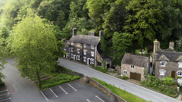
Overlooking the Station Yard is the aptly-name Station Hotel (now a restaurant called D’arcy’s at the Station), an imposing Grade II-listed, blue-brick, three-storey building originating at the same time as the railway.
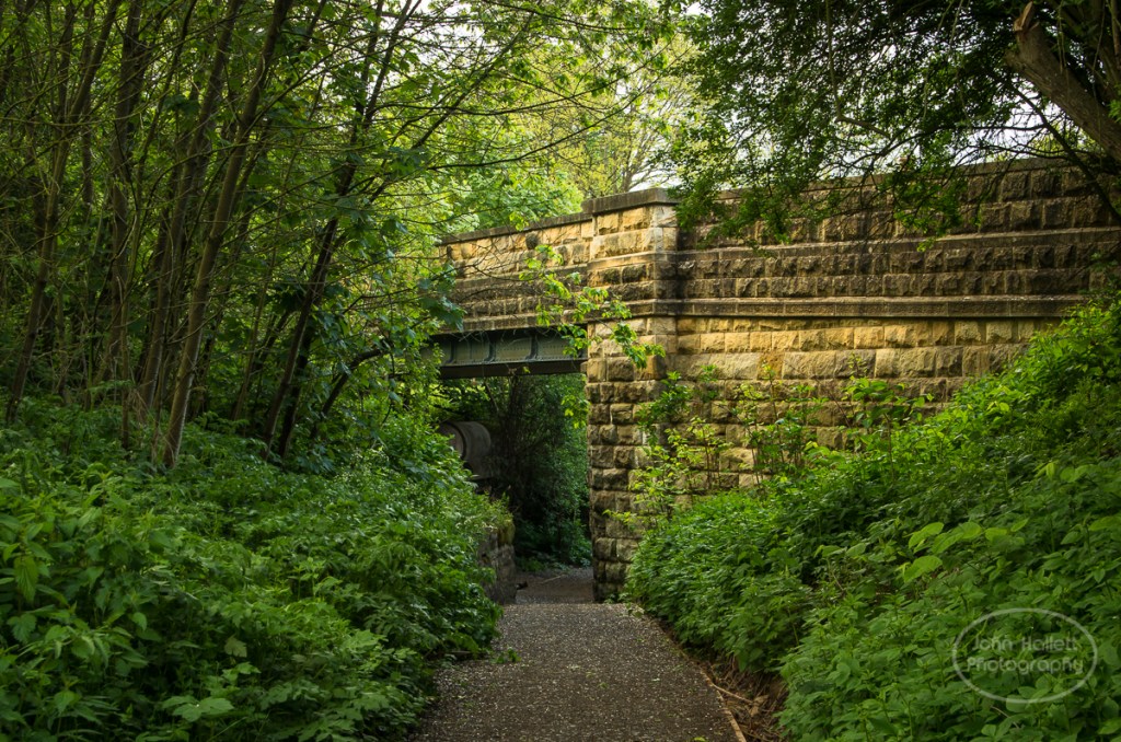
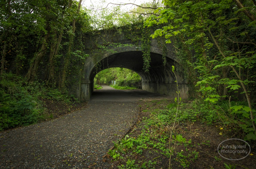
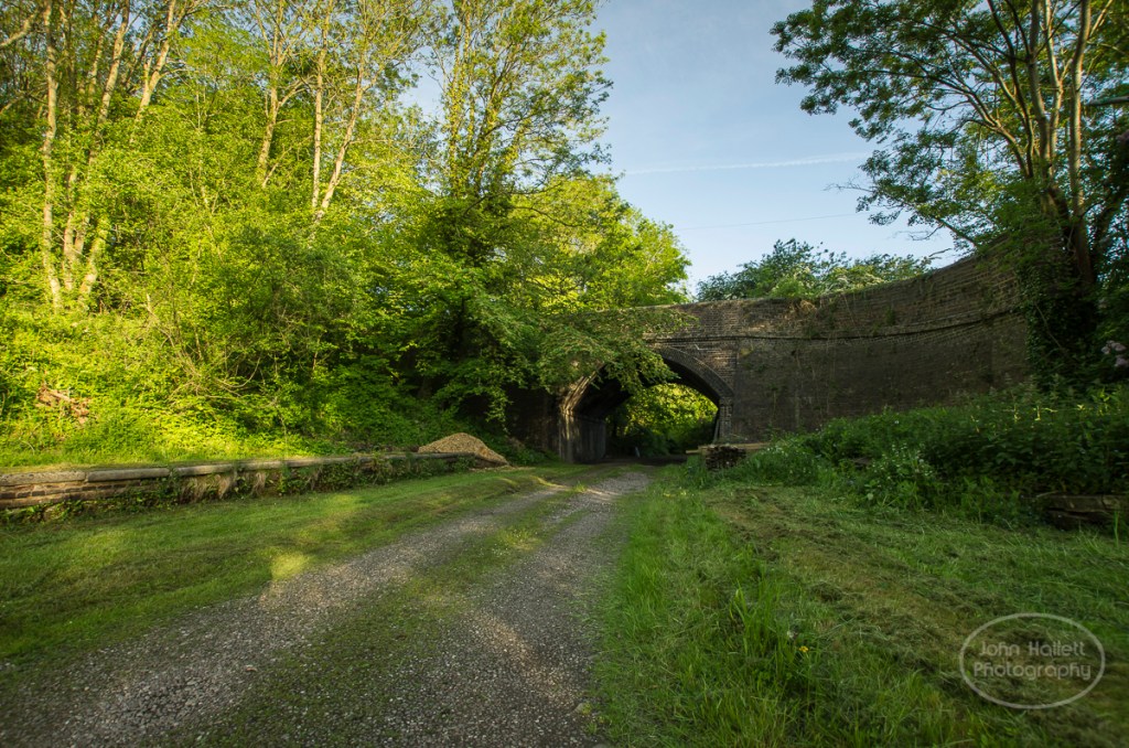
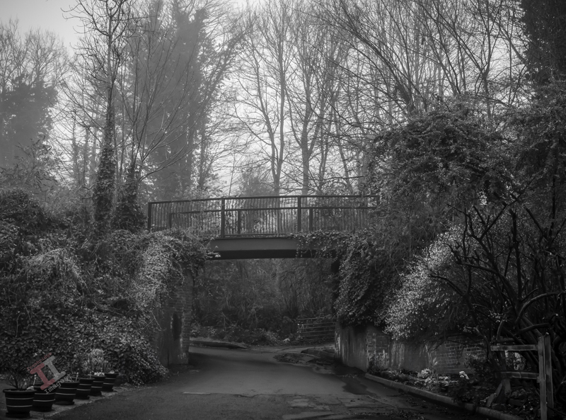
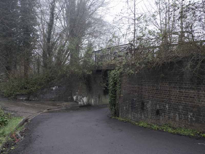
A little further on from the level crossing gates mentioned in Secret Ironbridge: Open Wide, and the Great Western Railway track-laying engineers must have thought that Christmas had come early when they came upon Chapel Lane at right-angles to the railways path.
All they needed to do was build some brick parapets and then drop a ready-made bridge on top, which was in contrast to most of the bridges in the Ironbridge Gorge that needed to be skew-bridges with complex brick-built abutments.
The ready-made bridge they chose was a Brymbo bridge, manufactured in the Denbighshire village of the same name. The Brymbo steel works operated from 1796 to 1991, and there are links with the Ironbridge Gorge because, in 1842, William Henry Darby and Charles Edward Darby (grandsons of Abraham Darby III who built the famous Iron Bridge here in the Ironbridge Gorge) were brought in to manage the works, and so would have been in charge when the little railway bridge was made.
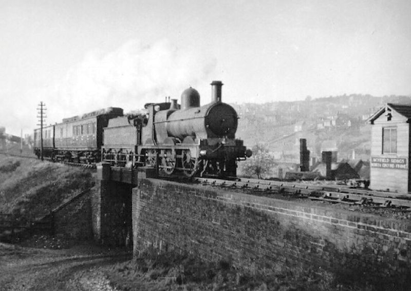
The original Brymbo bridge – photographer unknown
Some years ago major repairs were carried out, and little, if any, of the original Brymbo construction remains. It is now much narrower that the original and has a slight arch to it.
After passing under the bridge, you come across the Coalford Wesleyan chapel, built in 1825, that gave the lane its name (Coalford is an area within the village of Jackfield). John Wesley (1703-1791) was an English cleric and evangelist who led a Methodist religious movement within the Church of England that had its own places of worship in most towns and villages.
In 1884, the Wesleyan Methodists split away from the Church of England to form a new Christian denomination, and later, in 1932, there was a unification with the Primitive Methodists and the United Methodists to create what is now known as The Methodist Church.
The Coalford chapel closed in 1980 and is now used by a local brass band as their practice room.
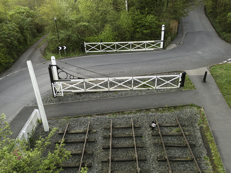
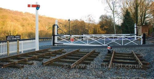
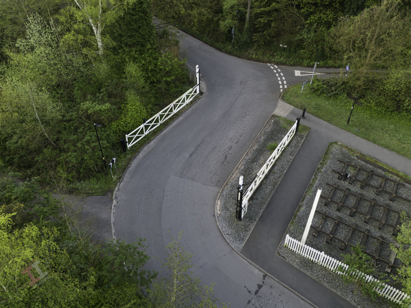
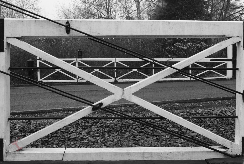
If you drive through the village of Jackfield, you will come to a dog-leg in the road as you cross, what was once, the Great Western Railway line.
This level-crossing is claimed, at 38 feet (11.5 metres), to be the widest in Britain. Although the railway line opened in 1862, it is likely that the wide gates were added later, as industry in the area expanded.
The current gates remain as a feature but are not the originals. During the last restoration in 2019, it was found that little of the wood was either original, or in very good condition, so it was decided to recreate them using past photographs as a guide (the original blueprints are long-gone).
Unfortunately, after the latest renovation, the signal post was retained but the metal signal arm was not. I must admit that for many years I thought this was an original, but closer inspection showed that it was made out of tin plate. However, I still liked it.
The level crossing in 2009.
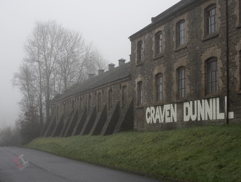
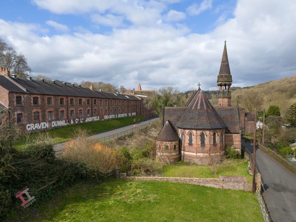
The main Great Western Railway line running from Bridgnorth through to Shrewsbury was only single-track. The reason for the wide level crossing was merely due to a complex set of sidings, which primarily served another tile manufacturer in the village: Craven Dunnill, who had the Jackfield Encaustic Tile Works purpose-built in 1872.
The Craven Dunnill factory opened some 12 years before the Maw family moved their tile works from Benthall to Jackfield (see Secret Ironbridge: Maw or less); a site also chosen due to its proximity to the railway, for easy transportation of raw materials in, and finished goods out.
The road now runs where the railway line used to be
The red line shows the position of the level crossing, with the Craven Dunnill factory bottom-right (C.1925)
To the west of the level crossing was a small railway platform which served W.P. Jones, another long-gone brick and tile works (as seen in the centre of the above map). The remains of the platform can still be seen in the undergrowth.
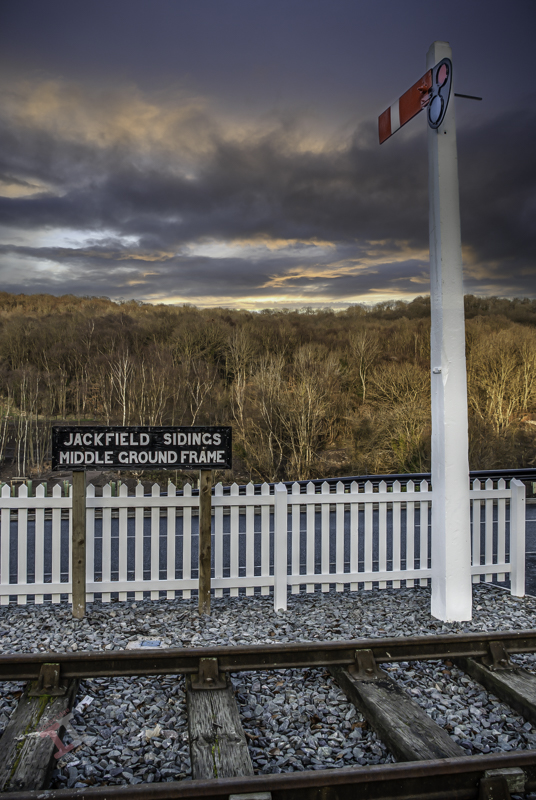
The sidings were controlled by sets of large levers on frames that opened and closed sets of points in the rails using interlinking rods or cables. These frames were mounted outside on the ground and were called, understandably, ‘ground frames’ (as opposed to those mounted inside signal boxes). There were three sets of ground frames at Jackfield, and the middle set were located by these level crossing gates.
Jackfield sidings
The South ground frame was located close to the entrance to the Craven Dunnill factory, adjacent to another level crossing with crossing gates. The North ground frame was located near a small railway bridge that is the subject of the next Secret Ironbridge instalment.
In an earlier blog post, Secret Ironbridge: Great Western Railway, we found that Coalport had two railway stations. Jackfield, another small village, had two churches, but why?
St Mary’s #1
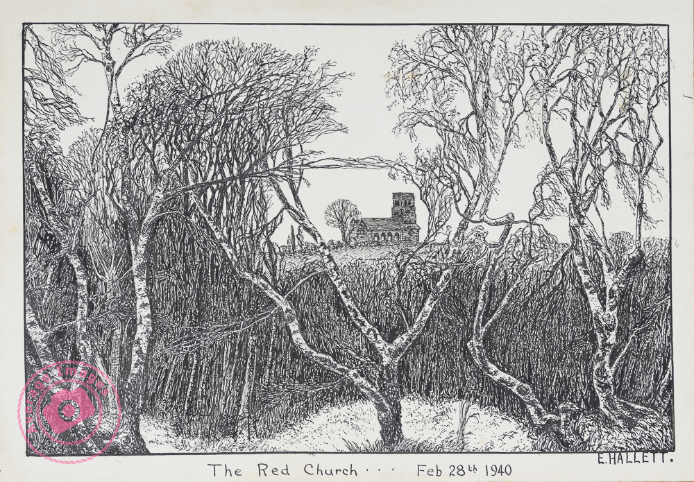
The ‘Red’ church had an official title of St Mary’s, but its colloquial name was coined from its construction (within an uncertain date range of 1759 to 1799) using local red brick.
The ‘Red’ church – as painted by my grandfather in 1940
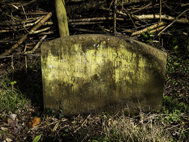
It was reputedly haunted, either by the lady who funded it and wanted it built in a specific alignment and/or by a young girl “wearing a bonnet, a flowing cape and carrying a lantern“. The latter possibly relates to a field fronting the church which holds a mass grave of victims of cholera pandemics in 1832 and 1848.
In 1850, the church’s morning attendance was recorded as 53 adults and 125 children, but services ceased just 10 years later. Some records report that it became unsafe due to ground movement, although it stayed standing (albeit as a ruin) for a further 100 years before being demolished in 1961.
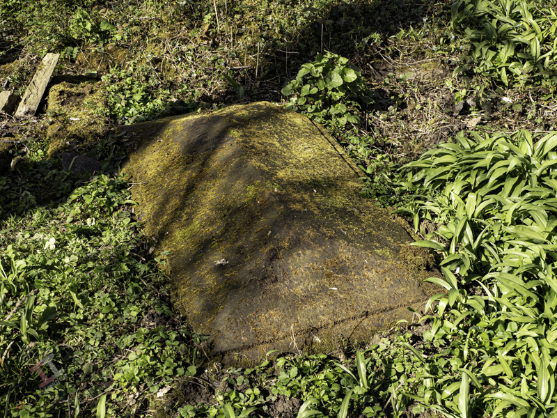
There is a volunteer group ‘Friends of the Red Church‘, currently working to restore the neglected graveyard, uncovering and sharing its history and that of people and events that shaped their lives.
At about the same time that services ceased at the Red church, there was a movement to erect a new church in the memory of George Pritchard, the late High Sheriff of Shropshire, who was credited with being the driving force to bring clean drinking water to the area, following the above-mentioned cholera outbreaks.
St Mary’s #2
In the early 1800s, Jackfield had established itself as an important river port, taking coal and other products made in nearby Broseley onto wharves supplying hundreds of river trows (flat-bottomed boats) plying their trade (at that time the river Severn was navigable and was the equivalent of todays motorways). The area was noisy and dirty and, with many migrant boatmen coming-and-going, was reputed to be an unsavoury place.
However, by the mid-1800s, the new Great Western Railway had been carved through the village, leading to the demolition of many houses and the decline of river transportation. New industry, namely brick and tile works, had sprung up, and with it, piles of waste product tipped onto the riverside where the wharves had once been. It was here that the new St Mary’s church was built.
Jackfield Church
Local manufacturers donated much of the materials, and it possibly ended up as a competition to see who could be seen to be the most generous, judging by the ornate brick and tile work.
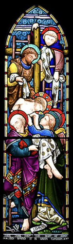
Windows at Jackfield church, Ironbridge Gorge.
The five windows depict: Agony in the Garden, Road to Golgotha, the Crucifixion, the Deposition, and the Resurrection.
You had one job…
How it is
An interesting fact is that the upper panel in one of the windows has been installed back-to-front.
How it should have been
In the next Secret Ironbridge blog post the Great Western Railway features again.
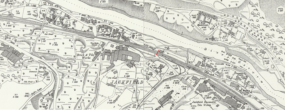
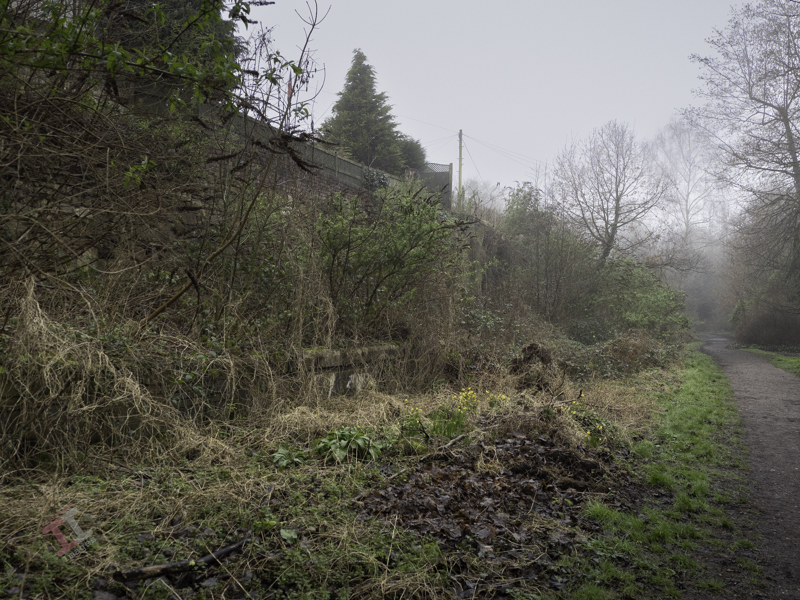
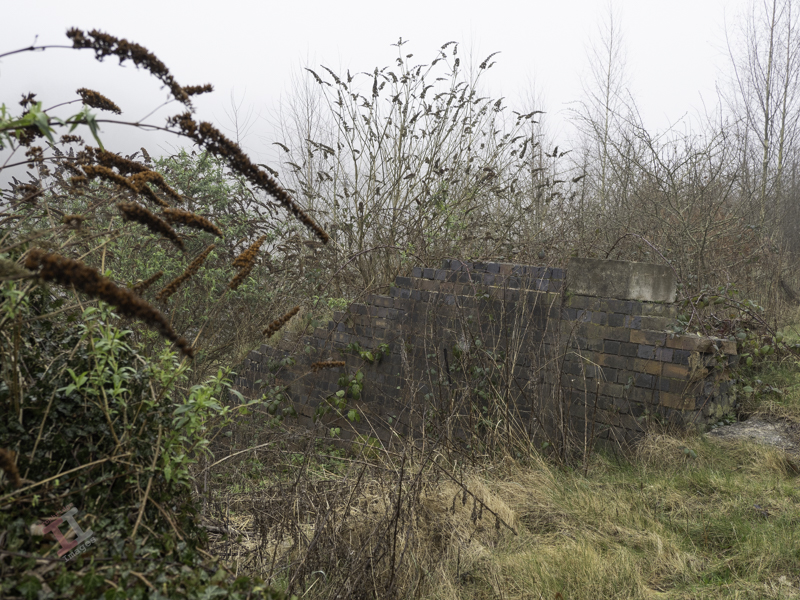
As I mentioned in a previous post; Secret Ironbridge – Great Western Railway, in 2003 I embarked on a project to photograph all 25 of the bridges in the Ironbridge Gorge. Only one of them is no longer standing, but the remains of its abutments can still just be seen, not far from the Maws tile works in Jackfield (see Secret Ironbridge – Maw or less).
The bridge itself was the victim of land slippage, which eventually led to significant stabilisation groundworks in 2015. At the time, the remains of the bridge were earmarked for removal, but they were saved at the last minute.
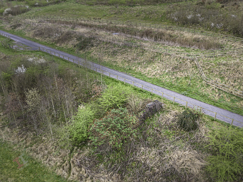
The bridge abutments can just be seen rising out of the undergrowth
Originally, the bridge only carried the single-track GWR through-line, but in about 1910, a siding was extended over the bridge, although it is not clear if it was widened to accommodate this.
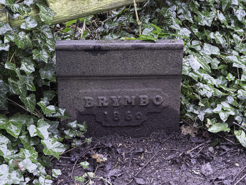
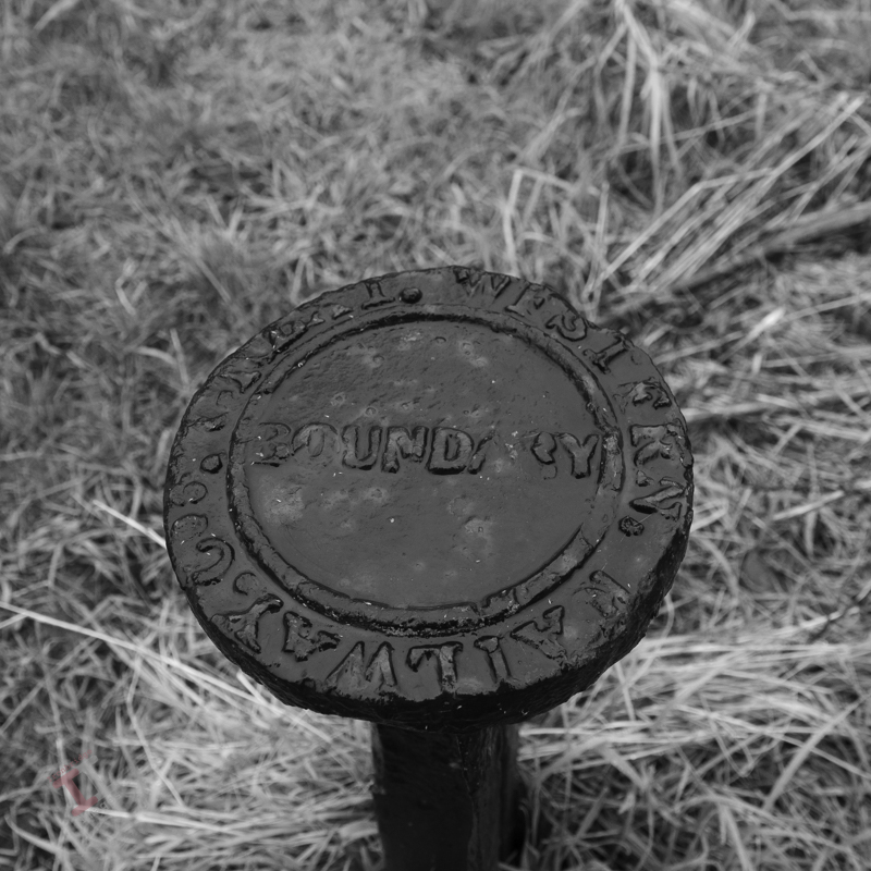
A GWR boundary post is situated nearby – although this is not its original position.
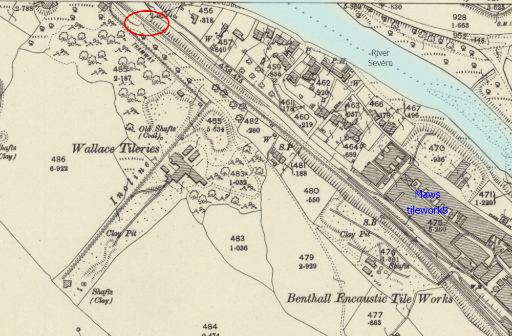
The bridge was built to cross a lane that provided access to Wallace Colliery, a very small coal mine that opened in the 1800s and is believed to include pits called ‘Bonny’ and ‘Jolly’. In the 1880s, attention turned to extracting clay, and Wallace Tileries was born on the same site, which quickly expanded, with a large building and even its own incline plane, tramway and railway siding linked to the GWR line. It was reputed to be the first roof tile works in the world with a tunnel kiln. It was short-lived; it had declined by 1920 and closed in the late 1930s, possibly due to the clay pits being exhausted.
Wallace Tileries in 1901. The bridge is circled in red.
There were some who believed that the closure, and subsequent cessation of pumping water from the pits, may have contributed to a significant landslide in 1952, when 27 dwellings were destroyed, as the ground on which they were built moved some 60 feet (18 metres) towards the river (the mines are directly above the area that was affected). There was, allegedly, an underground lake that could be seen down one of the pits. Perhaps unsurprisingly, official reports claim that this lack of pumping was unlikely to have caused the disaster.
Was the location of the tileries in relation to the landslide a coincidence? What do you think?
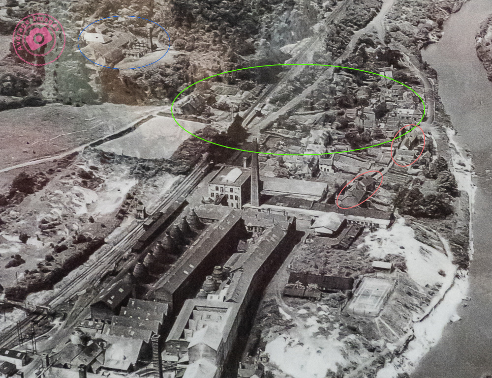
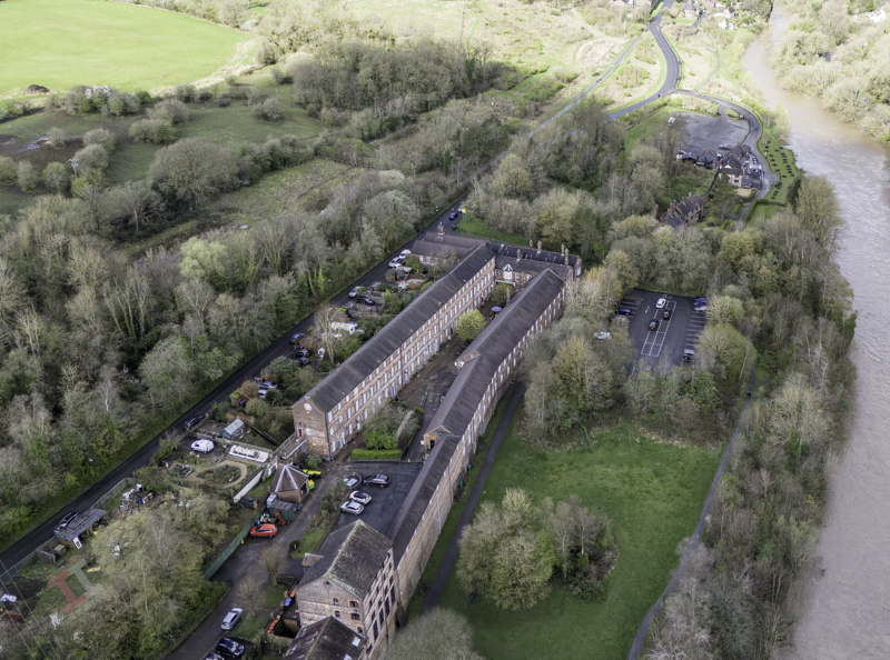
A 1942 aerial photograph, before the landslide. The Wallace Tileries are circled in blue, the houses affected in green. The houses circled in red still remain and can be seen in the image below.
A similar viewpoint today. See if you can spot the remaining buildings.
There is an interesting British Pathé news clip about the landslide on YouTube here, which also blames the cessation of pumping for the disaster.
The remains of the abutments are barely holding together
The abutments can just be seen. The footpath almost follows the line of the railway
Despite some considerable searching, I cannot find a photograph of the original bridge. It is very possible, given that the railway crossed the narrow lane at right angles, that it was a ready-made metal bridge laid on top of the brick abutments, similar to one that will be discussed in a later Secret Ironbridge blog post.
But that’s later; the next Secret Ironbridge blog post will be a little more ecclesiastical.