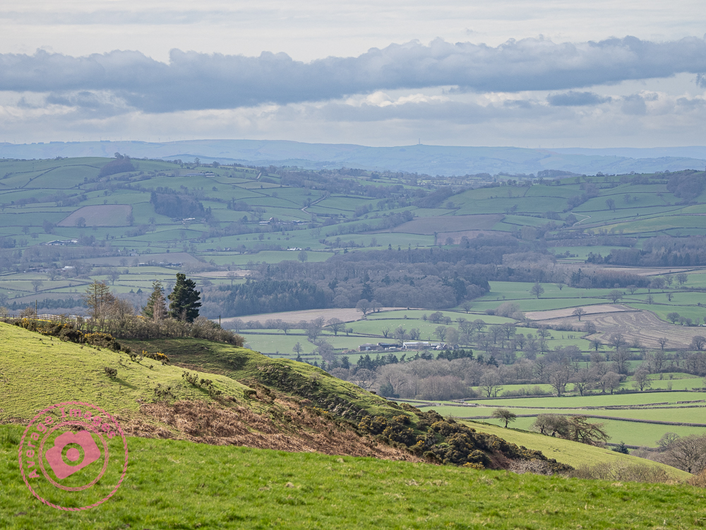
I’ve been immersed in photography for many years, exploring a variety of genres along the way. From capturing diverse landscapes to delving into the intricacies of still-life scenes, my lens has always been drawn to subjects with historical significance. It was inevitable that my work would feature the area where I grew up: the Ironbridge Gorge, which supplies almost limitless subjects on which to focus.
I have done a little rebranding with a new name, Ironbridge Images, which reflects my primary subject matter, and I’ve added a static front page to my website give continuity. The blog still remains, of course, albeit tucked inside the site. I have also consolidated my print sales and will now solely sell through my preferred print partner Photo4me, offering framed and unframed prints.
I hope you like the new look, and don’t forget to add a new bookmark or favourite to save the new web address.
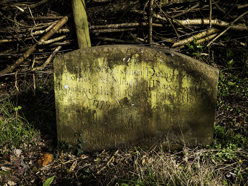
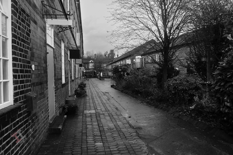
I’m going to hazard a guess that, after the famous bridge itself, this is the most photographed area of Ironbridge; Darlingtons shop and Severn Bank alley. It still has an ‘olde world’ look about it and is probably closer to what Ironbridge was really like in Victorian times than the local museum can ever try to replicate.
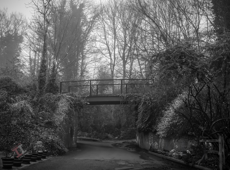
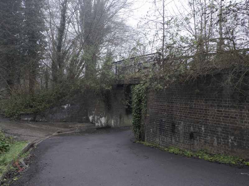
A little further on from the level crossing gates mentioned in Secret Ironbridge: Open Wide, and the Great Western Railway track-laying engineers must have thought that Christmas had come early when they came upon Chapel Lane at right-angles to the railways path.
All they needed to do was build some brick parapets and then drop a ready-made bridge on top, which was in contrast to most of the bridges in the Ironbridge Gorge that needed to be skew-bridges with complex brick-built abutments.
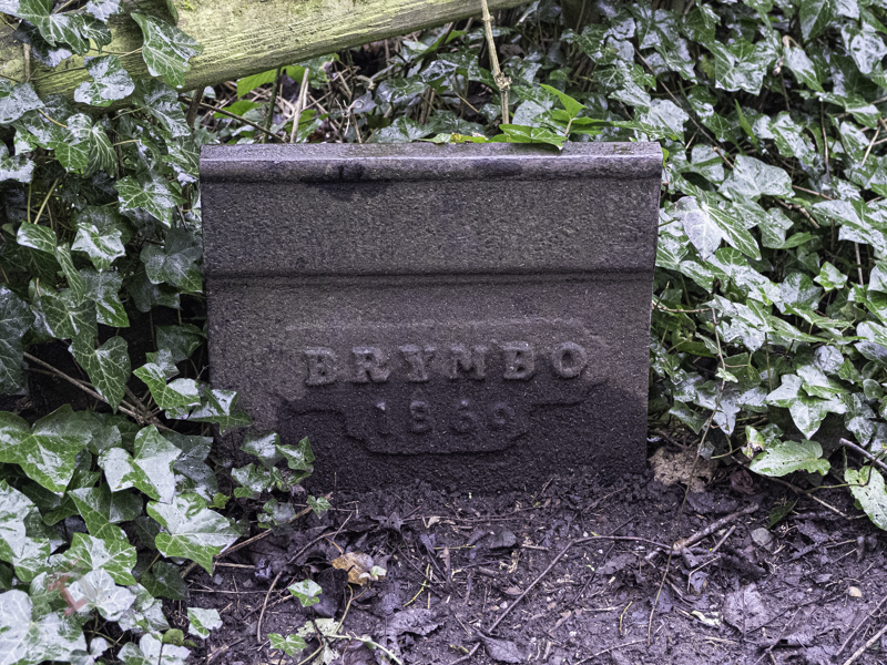
The ready-made bridge they chose was a Brymbo bridge, manufactured in the Denbighshire village of the same name. The Brymbo steel works operated from 1796 to 1991, and there are links with the Ironbridge Gorge because, in 1842, William Henry Darby and Charles Edward Darby (grandsons of Abraham Darby III who built the famous Iron Bridge here in the Ironbridge Gorge) were brought in to manage the works, and so would have been in charge when the little railway bridge was made.
The original Brymbo bridge – photographer unknown
Some years ago major repairs were carried out, and little, if any, of the original Brymbo construction remains. It is now much narrower that the original and has a slight arch to it.
After passing under the bridge, you come across the Coalford Wesleyan chapel, built in 1825, that gave the lane its name (Coalford is an area within the village of Jackfield). John Wesley (1703-1791) was an English cleric and evangelist who led a Methodist religious movement within the Church of England that had its own places of worship in most towns and villages.
In 1884, the Wesleyan Methodists split away from the Church of England to form a new Christian denomination, and later, in 1932, there was a unification with the Primitive Methodists and the United Methodists to create what is now known as The Methodist Church.
The Coalford chapel closed in 1980 and is now used by a local brass band as their practice room.
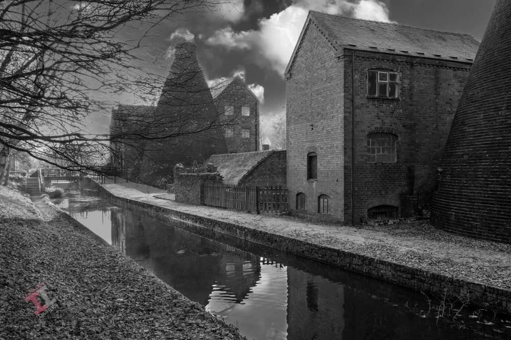
This is a shot of Coalport China Works, just a short walk from my house. It was taken at the end of a particularly damp November, and the towpath was covered in a luminous green moss, which was quite distracting. By removing the colour, that distracting green moss becomes a leading line to take the eye through the image.
Coalport China Works
If you have read my blog post; Secret Ironbridge: Transhipment interchange, you will know that Coalport was a ‘new town’ built in the 1790s to service a wharfage between the Shropshire Canal and the River Severn. At about the same time, entrepreneur John Rose had a china factory built on the same site to take advantage of the distribution opportunities that the new canal and river provided.
The remains of the factory (now a museum) are easily recognisable by the two bottle kilns (the name refers to their shape) used to ‘fire’ the pottery. Their distinct profile created an updraught that accelerated the heat from fires at their base. Bottle kilns were very inefficient, but continued to be used throughout the UK until well into the mid-1900s.
Bottle kilns were a common site in the Ironbridge Gorge; the Coalport site originally had six, but there were many more over the river at the Maws and Craven Dunnill tile works.
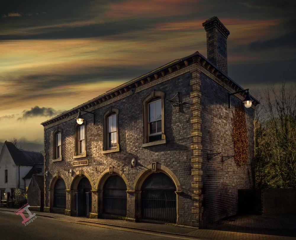
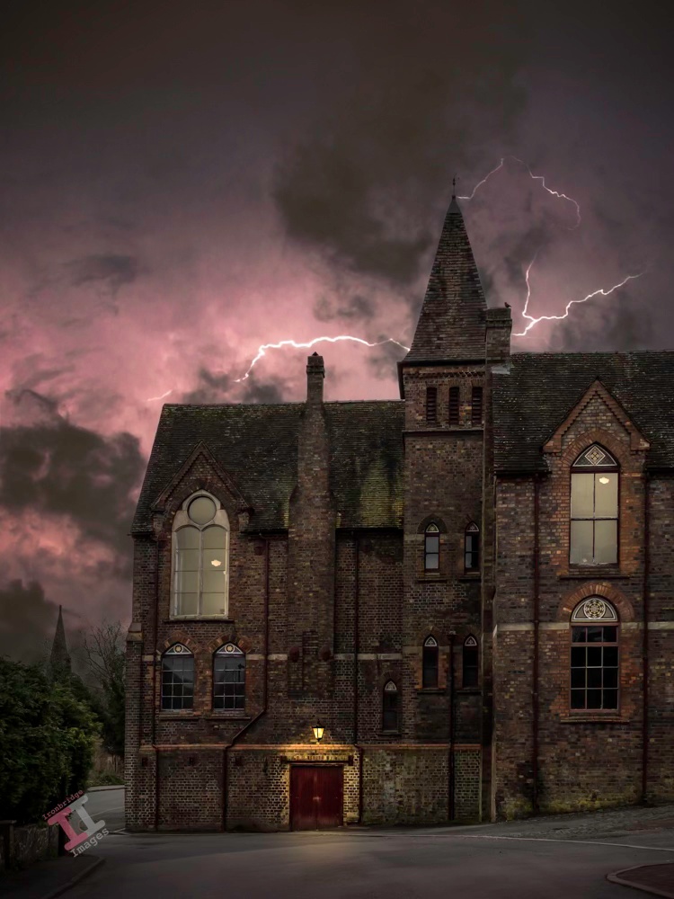
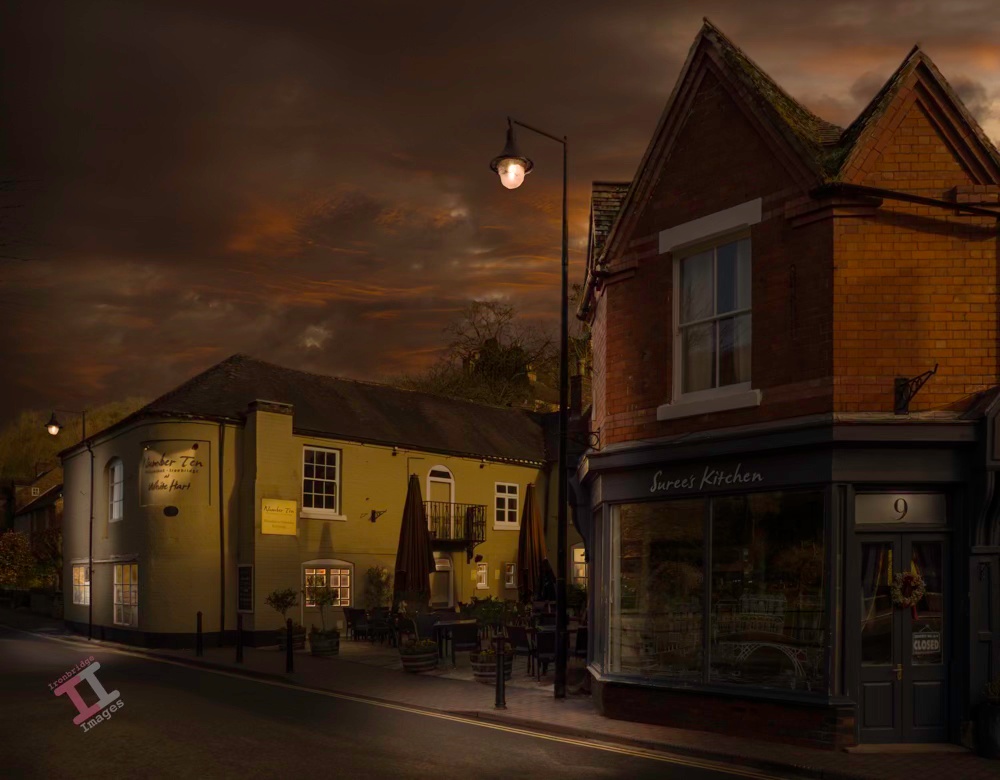
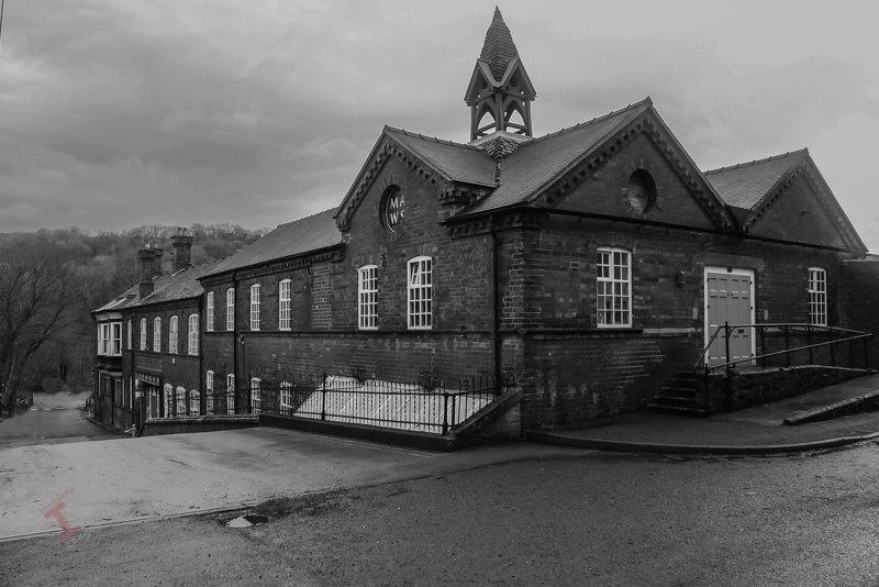
This is the old police station and court house on Waterloo Street in Ironbridge, Shropshire. It was built in 1862 in an Italianate style, with blue bricks and white brick and stone dressings, by a local builder and architect, Samuel Nevett. Similar buildings were built by him in the Ironbridge Gorge with a similar style. Until recently, it was a very fine Indian restaurant called Pondecherry, but unfortunately the economic downturn meant that is was unsustainable and it has closed. The building is currently empty. The image is another from my day-to-night project, processed in Adobe Lightroom and Photoshop.
I firmly believe that the best black-and-white photographs are those that are taken specifically for that genre. However, there is also a common saying:
“If the colour ain’t right, go black & white”
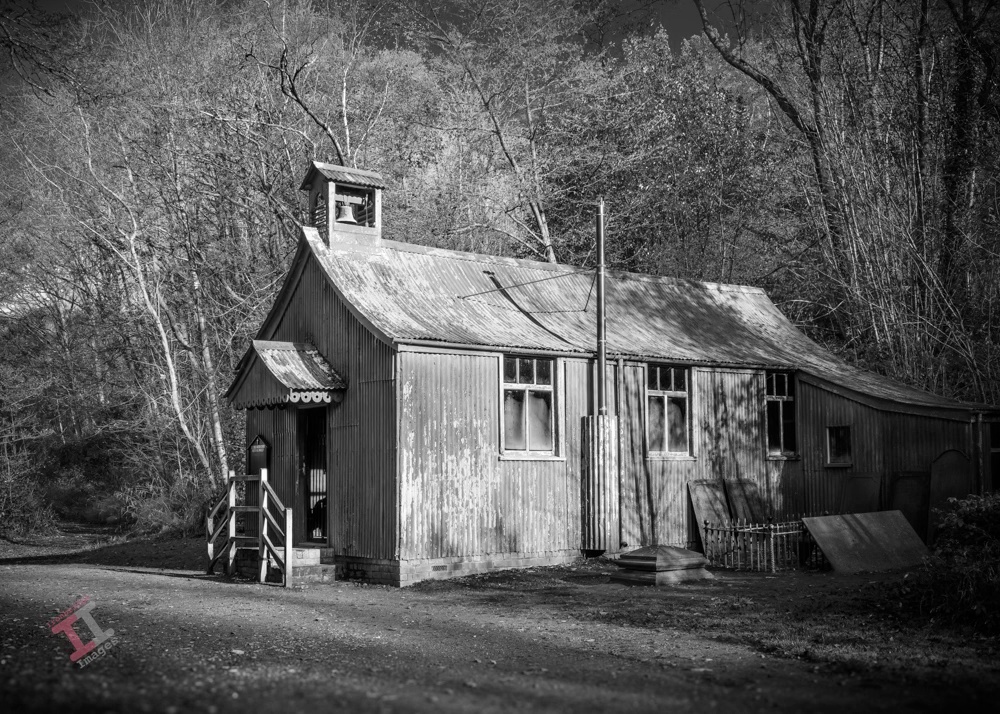
Actually, I’m not sure that it is a common saying, but the image here is a case in point. It has been lying on my hard drive for a couple of years; there was something about it I liked, but the colours just didn’t work. The subject is St Chads Mission Church, a prefabricated corrugated-iron building dating from 1888, originally built at Granville Colliery in Shropshire but now moved into an open-air museum complex. It has been painted, at some time, with a red paint (presumably red-lead, to prevent corrosion) which is a bit garish in a photograph, which I why I never used it.
St Chads Church
However, by removing colour entirely, it produces a much more satisfying image. Of course, this doesn’t just mean desaturating the image of colour, it needs careful post-processing (in much the same way as a colour image) in order to achieve the best tonal values. I use Adobe Lightroom and Photoshop for the task, although many favour a program called Nik Silver Efex.
There is a common error made confusing the terms ‘black-and-white‘ with ‘monochrome‘. A monochrome image is one made up of shades of only one colour (plus white), so this term obviously includes a ‘black and white’ image, as well as a sepia image and a cyanotype. Therefore a ‘black-and-white’ image is a monochrome, but a monochrome isn’t necessarily ‘black-and-white’.
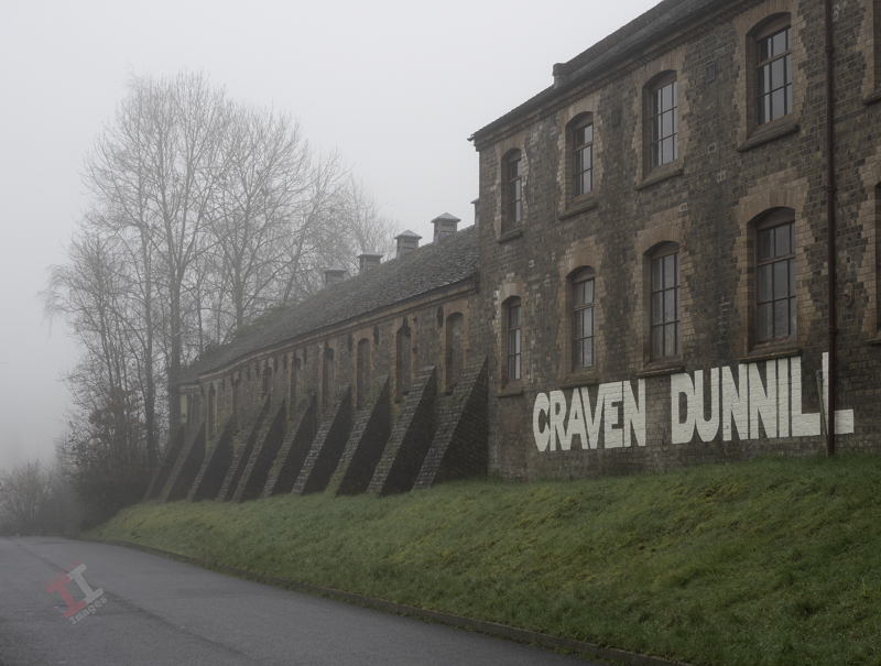
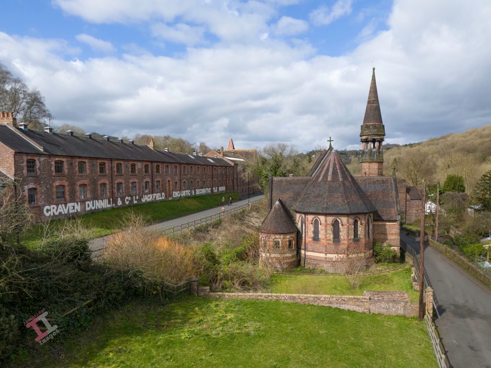
Following on from my recent Secret Ironbridge: Open Wide post, here is the nearby Craven Dunnill Encaustic Tile Works, which was purpose-built at Jackfield, in the Ironbridge Gorge, in 1872. Its formidable appearance lent itself well to this Harry Potter type processing, complemented by the bird that helpfully sat on the roof as I took the shot.
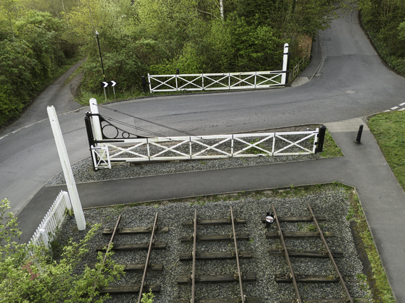
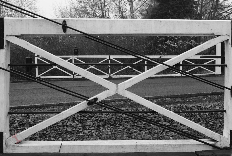
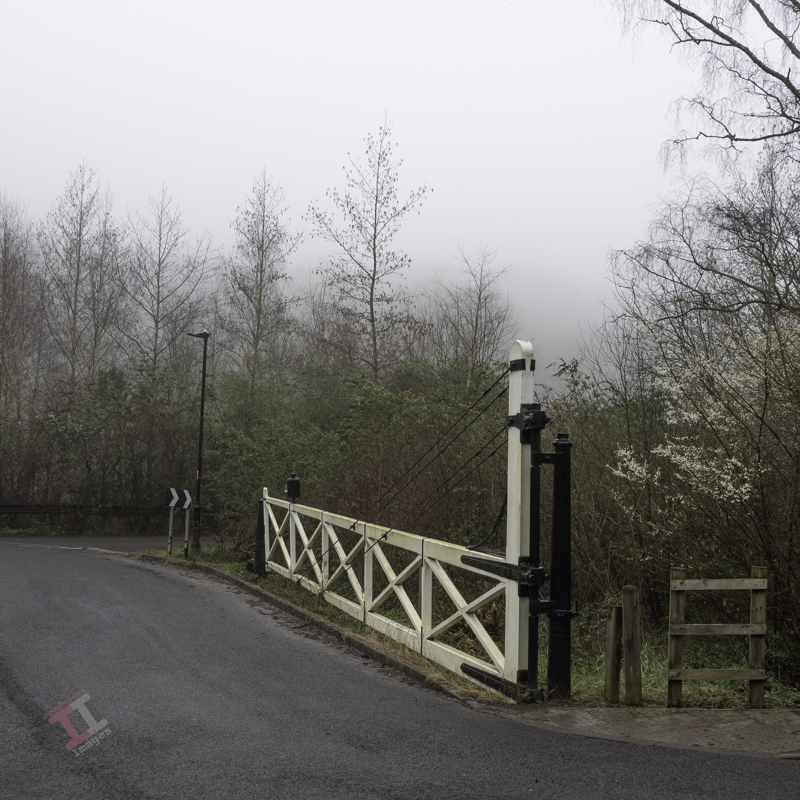
If you drive through the village of Jackfield, you will come to a dog-leg in the road as you cross, what was once, the Great Western Railway line.
This level-crossing is claimed, at 38 feet (11.5 metres), to be the widest in Britain. Although the railway line opened in 1862, it is likely that the wide gates were added later, as industry in the area expanded.
The current gates remain as a feature but are not the originals. During the last restoration in 2019, it was found that little of the wood was either original, or in very good condition, so it was decided to recreate them using past photographs as a guide (the original blueprints are long-gone).
Unfortunately, after the latest renovation, the signal post was retained but the metal signal arm was not. I must admit that for many years I thought this was an original, but closer inspection showed that it was made out of tin plate. However, I still liked it.
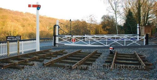
The level crossing in 2009.
The main Great Western Railway line running from Bridgnorth through to Shrewsbury was only single-track. The reason for the wide level crossing was merely due to a complex set of sidings, which primarily served another tile manufacturer in the village: Craven Dunnill, who had the Jackfield Encaustic Tile Works purpose-built in 1872.
The Craven Dunnill factory opened some 12 years before the Maw family moved their tile works from Benthall to Jackfield (see Secret Ironbridge: Maw or less); a site also chosen due to its proximity to the railway, for easy transportation of raw materials in, and finished goods out.
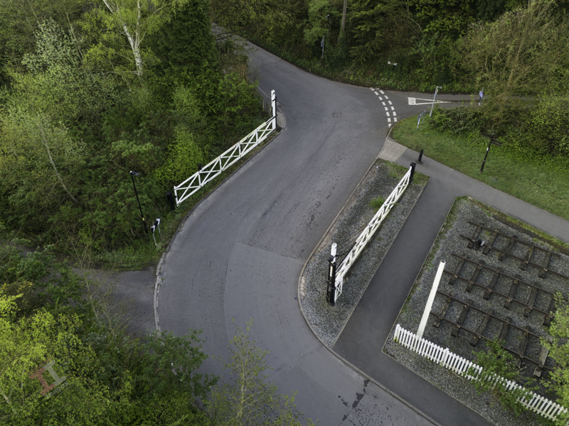
The road now runs where the railway line used to be
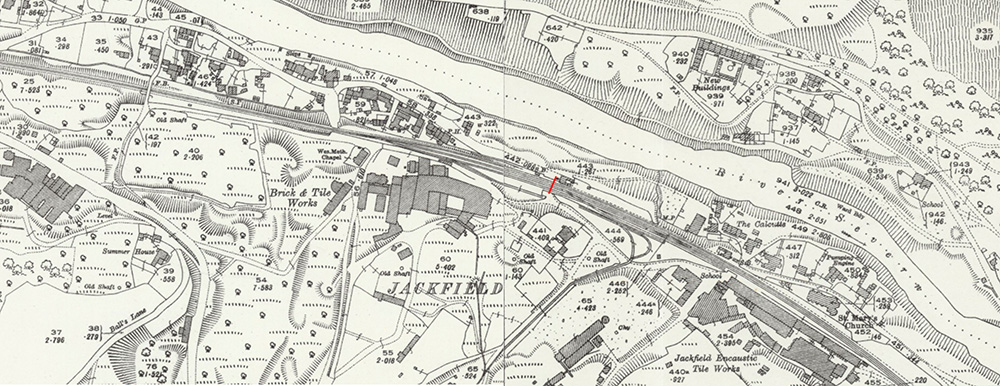
The red line shows the position of the level crossing, with the Craven Dunnill factory bottom-right (C.1925)
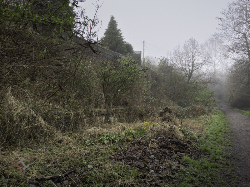
To the west of the level crossing was a small railway platform which served W.P. Jones, another long-gone brick and tile works (as seen in the centre of the above map). The remains of the platform can still be seen in the undergrowth.
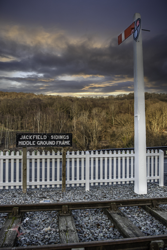
The sidings were controlled by sets of large levers on frames that opened and closed sets of points in the rails using interlinking rods or cables. These frames were mounted outside on the ground and were called, understandably, ‘ground frames’ (as opposed to those mounted inside signal boxes). There were three sets of ground frames at Jackfield, and the middle set were located by these level crossing gates.
Jackfield sidings
The South ground frame was located close to the entrance to the Craven Dunnill factory, adjacent to another level crossing with crossing gates. The North ground frame was located near a small railway bridge that is the subject of the next Secret Ironbridge instalment.
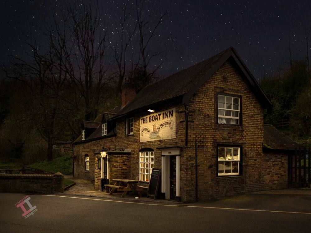
The subject of this image is the Boat Inn at Jackfield in the Ironbridge Gorge, Shropshire, probably best known for being flooded by the River Severn every time it bursts its banks in the winter. Talking of ‘banks’, the sign above the door is testament that it was once tied to the Banks’ brewery, which had this motto.
This is another day-to-night image, post-processed with Adobe Lightroom and Photoshop.
In an earlier blog post, Secret Ironbridge: Great Western Railway, we found that Coalport had two railway stations. Jackfield, another small village, had two churches, but why?
St Mary’s #1
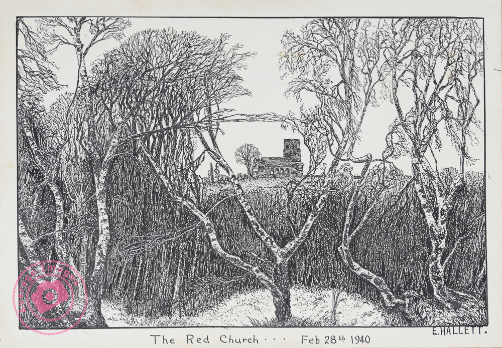
The ‘Red’ church had an official title of St Mary’s, but its colloquial name was coined from its construction (within an uncertain date range of 1759 to 1799) using local red brick.
The ‘Red’ church – as painted by my grandfather in 1940
It was reputedly haunted, either by the lady who funded it and wanted it built in a specific alignment and/or by a young girl “wearing a bonnet, a flowing cape and carrying a lantern“. The latter possibly relates to a field fronting the church which holds a mass grave of victims of cholera pandemics in 1832 and 1848.
In 1850, the church’s morning attendance was recorded as 53 adults and 125 children, but services ceased just 10 years later. Some records report that it became unsafe due to ground movement, although it stayed standing (albeit as a ruin) for a further 100 years before being demolished in 1961.
There is a volunteer group ‘Friends of the Red Church‘, currently working to restore the neglected graveyard, uncovering and sharing its history and that of people and events that shaped their lives.
At about the same time that services ceased at the Red church, there was a movement to erect a new church in the memory of George Pritchard, the late High Sheriff of Shropshire, who was credited with being the driving force to bring clean drinking water to the area, following the above-mentioned cholera outbreaks.
St Mary’s #2
In the early 1800s, Jackfield had established itself as an important river port, taking coal and other products made in nearby Broseley onto wharves supplying hundreds of river trows (flat-bottomed boats) plying their trade (at that time the river Severn was navigable and was the equivalent of todays motorways). The area was noisy and dirty and, with many migrant boatmen coming-and-going, was reputed to be an unsavoury place.
However, by the mid-1800s, the new Great Western Railway had been carved through the village, leading to the demolition of many houses and the decline of river transportation. New industry, namely brick and tile works, had sprung up, and with it, piles of waste product tipped onto the riverside where the wharves had once been. It was here that the new St Mary’s church was built.
Jackfield Church
Local manufacturers donated much of the materials, and it possibly ended up as a competition to see who could be seen to be the most generous, judging by the ornate brick and tile work.
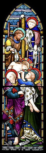
Windows at Jackfield church, Ironbridge Gorge.
The five windows depict: Agony in the Garden, Road to Golgotha, the Crucifixion, the Deposition, and the Resurrection.
You had one job…
How it is
An interesting fact is that the upper panel in one of the windows has been installed back-to-front.
How it should have been
In the next Secret Ironbridge blog post the Great Western Railway features again.
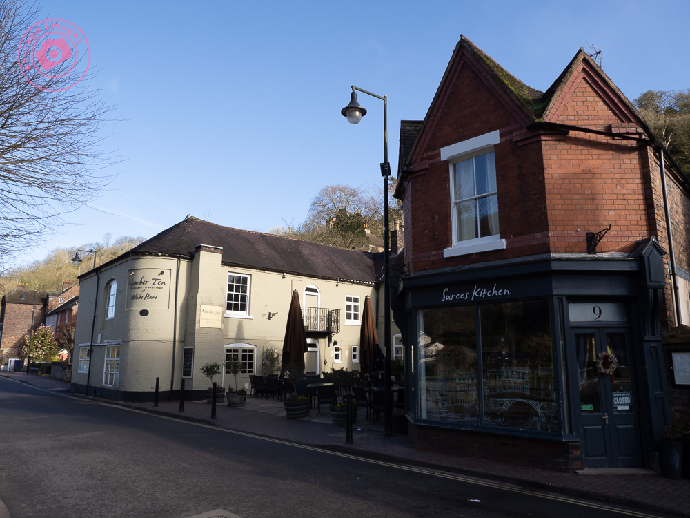
It was a shot that I had planned for weeks. Late in the evening I set up my tripod and tucked into a corner of the pavement to keep out of the way of any drunken revellers. The courtyard of the public house was thronging with an unexpectedly large crowd of people, constantly moving around, and the sky was overcast, covered with a thick layer of cloud. It looked as if my plans had come to nothing. Suddenly, everyone dispersed as if on command, and the clouds parted sufficiently to let the setting sun cast an orange glow over their edges. I fired the shutter and captured just one shot before the bar emptied its customers onto the pavement and rain clouds arrived overhead. It was time to go home.
Sounds like a great photographers story, and similar to those that you can read in most photography magazines. But it didn’t happen!
This is actually a classic day-to-night image conversion carried out in post-processing. The original image is here to the right, and was captured at 8am on Saturday morning (hence the distinct lack of people). I deliberately took the image for such a conversion and so wasn’t too worried about the contrast in the scene or the converging verticals.
These day-to-night conversions favour architectural shots, particularly when windows and exterior lights can be ‘lit’ to create character. I am fortunate to live in the Ironbridge Gorge, which contains many interesting buildings (and quirky street lamps) and so I can take the ‘stock’ images as I am walking our dogs in the morning (as I did here), without having to concern myself too much with the quality of light.
The conversion itself was carried out with a combination of Adobe Lightroom and Photoshop. It entailed a sky replacement and a plethora of light masks, and so took a fair amount of time – but I did enjoy the process of deciding what the incidental illumination from each light source should be, and how shadows would be cast.
I enjoyed it so much that I’m going to do some more! If you want to see them as they are posted, then subscribe to this blog (for free!) to keep up-to-date via your email inbox or the Reader app.
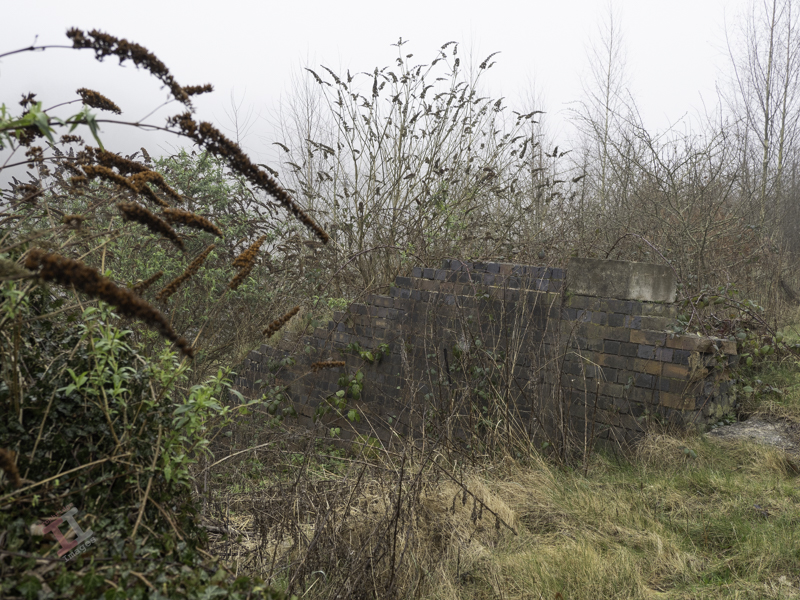
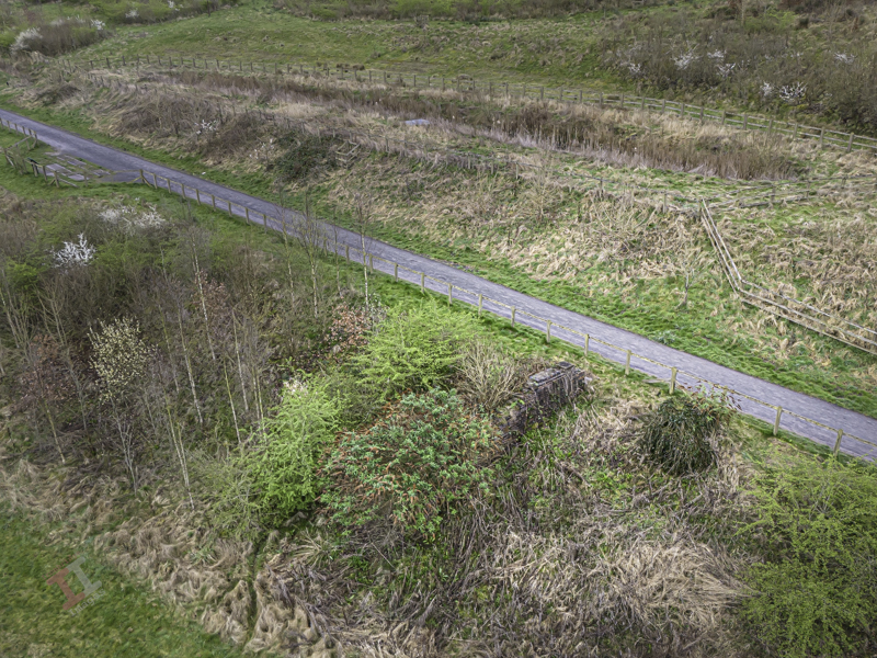
As I mentioned in a previous post; Secret Ironbridge – Great Western Railway, in 2003 I embarked on a project to photograph all 25 of the bridges in the Ironbridge Gorge. Only one of them is no longer standing, but the remains of its abutments can still just be seen, not far from the Maws tile works in Jackfield (see Secret Ironbridge – Maw or less).
The bridge itself was the victim of land slippage, which eventually led to significant stabilisation groundworks in 2015. At the time, the remains of the bridge were earmarked for removal, but they were saved at the last minute.
The bridge abutments can just be seen rising out of the undergrowth
Originally, the bridge only carried the single-track GWR through-line, but in about 1910, a siding was extended over the bridge, although it is not clear if it was widened to accommodate this.
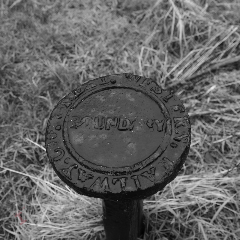
A GWR boundary post is situated nearby – although this is not its original position.
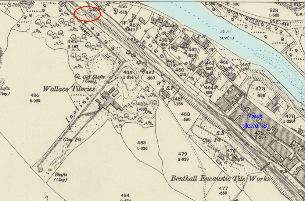
The bridge was built to cross a lane that provided access to Wallace Colliery, a very small coal mine that opened in the 1800s and is believed to include pits called ‘Bonny’ and ‘Jolly’. In the 1880s, attention turned to extracting clay, and Wallace Tileries was born on the same site, which quickly expanded, with a large building and even its own incline plane, tramway and railway siding linked to the GWR line. It was reputed to be the first roof tile works in the world with a tunnel kiln. It was short-lived; it had declined by 1920 and closed in the late 1930s, possibly due to the clay pits being exhausted.
Wallace Tileries in 1901. The bridge is circled in red.
There were some who believed that the closure, and subsequent cessation of pumping water from the pits, may have contributed to a significant landslide in 1952, when 27 dwellings were destroyed, as the ground on which they were built moved some 60 feet (18 metres) towards the river (the mines are directly above the area that was affected). There was, allegedly, an underground lake that could be seen down one of the pits. Perhaps unsurprisingly, official reports claim that this lack of pumping was unlikely to have caused the disaster.
Was the location of the tileries in relation to the landslide a coincidence? What do you think?
A 1942 aerial photograph, before the landslide. The Wallace Tileries are circled in blue, the houses affected in green. The houses circled in red still remain and can be seen in the image below.
A similar viewpoint today. See if you can spot the remaining buildings.
There is an interesting British Pathé news clip about the landslide on YouTube here, which also blames the cessation of pumping for the disaster.
The remains of the abutments are barely holding together
The abutments can just be seen. The footpath almost follows the line of the railway
Despite some considerable searching, I cannot find a photograph of the original bridge. It is very possible, given that the railway crossed the narrow lane at right angles, that it was a ready-made metal bridge laid on top of the brick abutments, similar to one that will be discussed in a later Secret Ironbridge blog post.
But that’s later; the next Secret Ironbridge blog post will be a little more ecclesiastical.
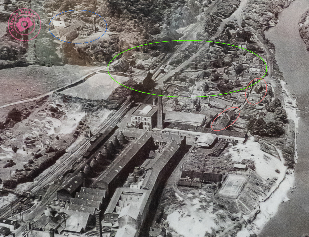
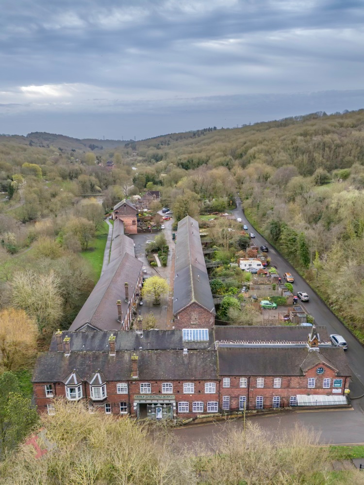
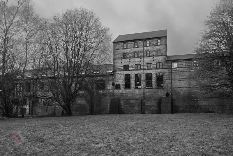
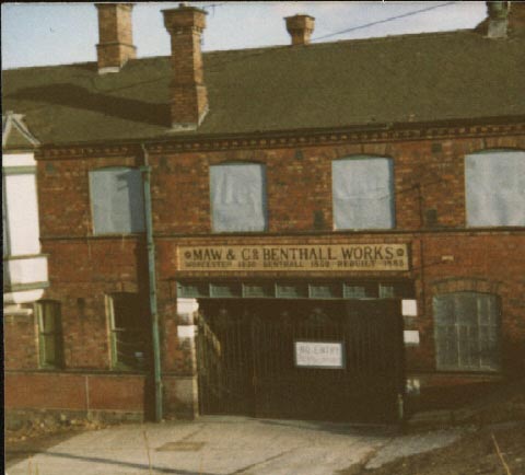
In Victorian times, the Ironbridge Gorge was home to numerous brick and tile works, due to the abundance of coal and, of course, clay. Most of these were small concerns, but occasionally a business would expand exponentially and become a major part of the community. An example of this is Maws and Co. in Jackfield.
Maw or less
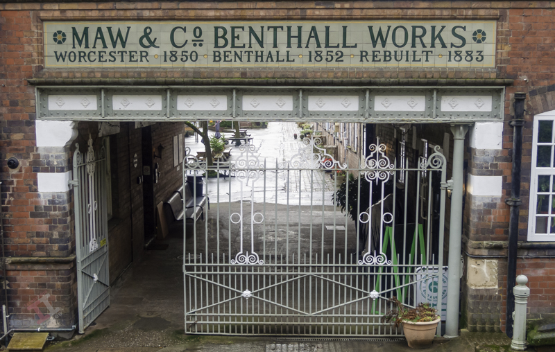
The company was founded in Worcester in 1850 by John Hornby Maw and his two sons, George and Arthur, but the shortage of good quality clay in that area meant that they shifted the entire operation (including the employees) to Benthall, near Broseley, in 1852. To take advantage of the transportation opportunities of the new Great Western Railway line, the site relocated again in 1883 to the site of an existing brickworks at Jackfield (this explains the somewhat confusing name “Benthall Works” above the entrance).
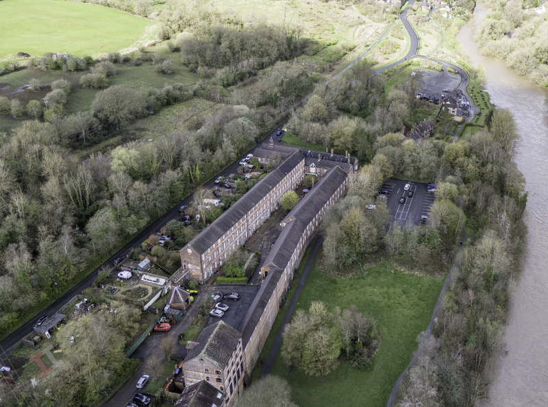
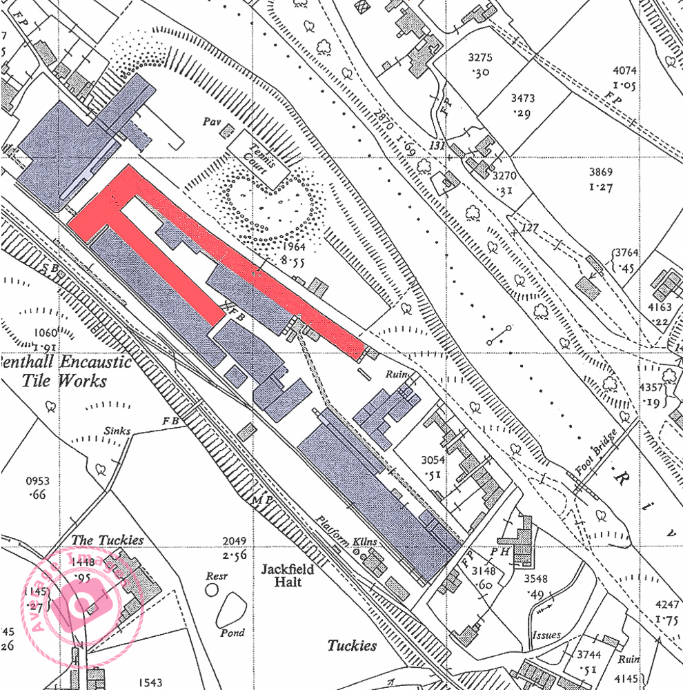
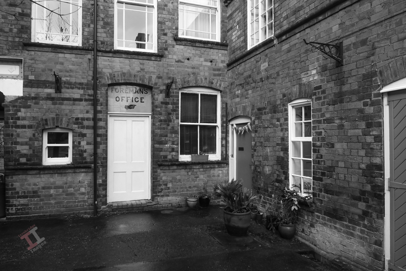
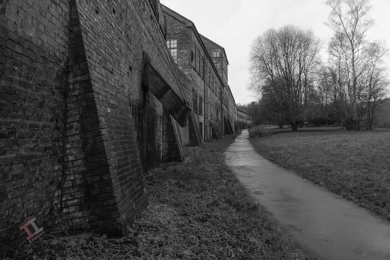
Today, you will find the works if you follow the signs to the Maws Craft Centre – its courtyard now taken up by artisan craft shops. As you walk down the courtyard you may be impressed by the size of the buildings – but in reality this is just one third of the size of the original works – the majority demolished in the 1970s. The map below shows the remaining buildings in red – with the rest of the (now demolished) works in blue. You will also notice that it had its own railway platform and sidings from the GWR line (see Secret Ironbridge: Great Western Railway) – the current road didn’t exist at that time. In its heyday, it was the largest encaustic tileworks in the world and employed 400 people.
A 1955 map showing the Maws works at the time. Only the buildings in red exist today.
Sadly, after the First World War, the ceramic tile industry went into a slow decline and after a merger, and then a take-over, the works finally closed in January 1970.
The Works all boarded up in the 1970’s
After years of dereliction the courtyard was converted into small workshop units and the upper storeys into apartments. The buildings live again!
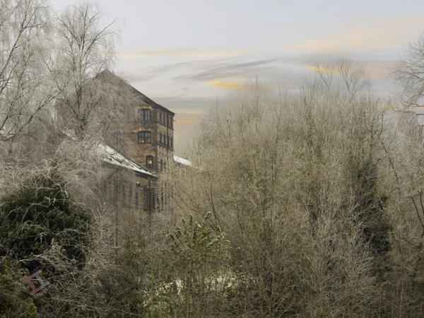
Frosty morning at Maws
Coal chute on Ferry Road
The Great Western Railway played a big part in the evolution of Jackfield, from a fairly squalid river port to a hive of industry. In the next Secret Ironbridge blog post we will visit a lost railway bridge, and its link to another tile works – one that may have helped to destroy part of the village!
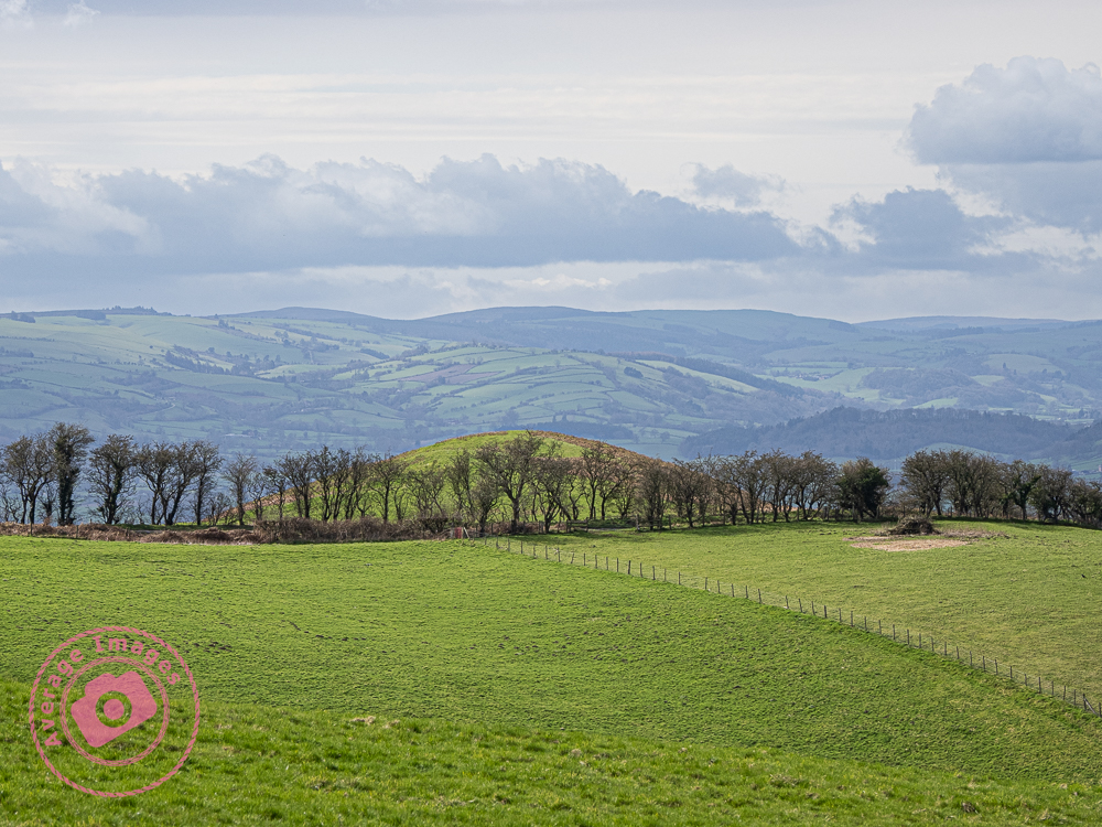
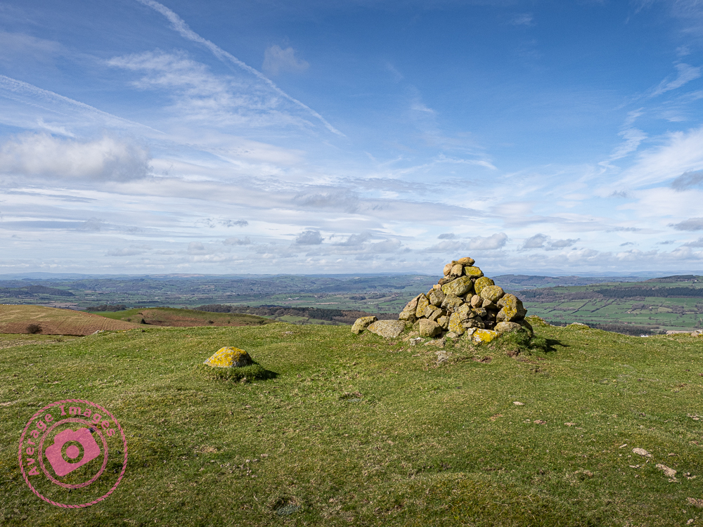
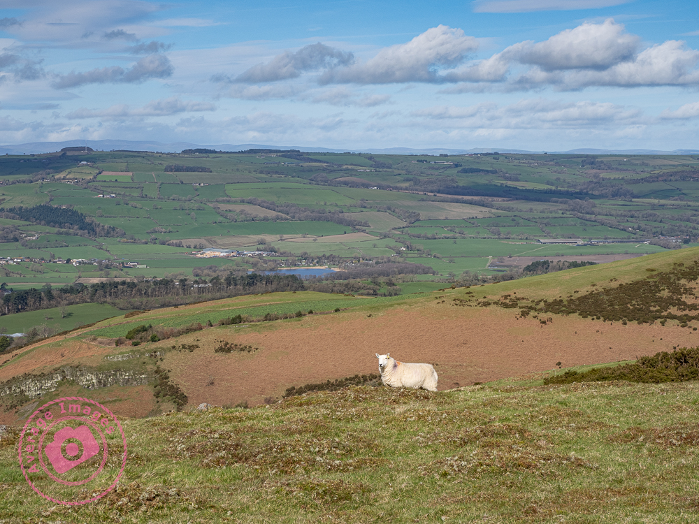
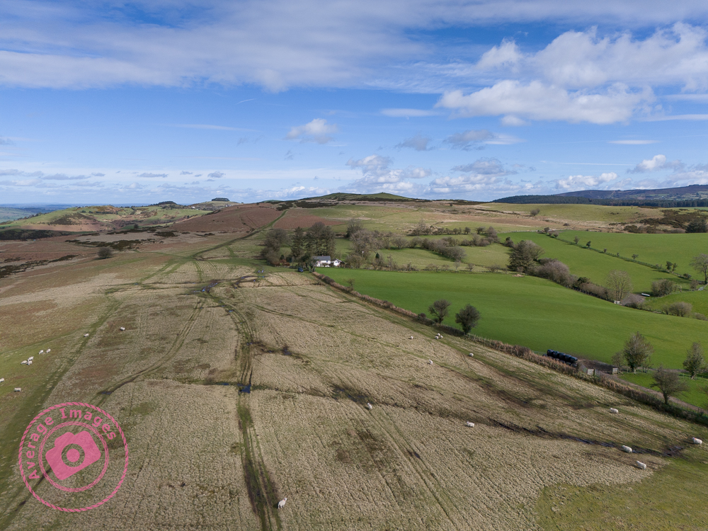
Today is Mrs H’s birthday and so we celebrated by taking the dogs for a walk in the Spring sunshine. We opted to visit the the Mitchell’s Fold stone circle at Stapeley Hill, just over the Welsh border, close to Montgomery. It was a good trek across the moorland, very muddy in places (following the long, wet, Winter) and quite breezy at the top of the hill, but otherwise very pleasant in the warm sunlight.
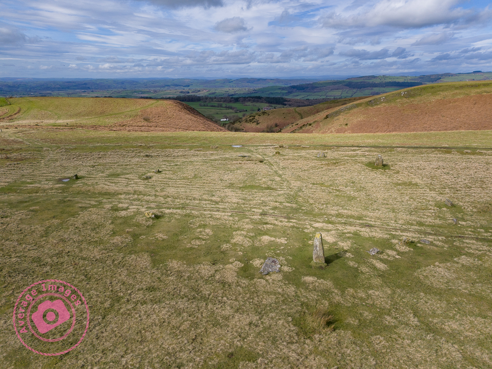
The stone circle was built in the Bronze Age, about 3,000 years ago. There are fifteen stones (although it is thought that originally there were thirty) but it is unknown exactly why they were built – some think it was for religious reasons, others that it acted as a form of calendar. As stone circles go, the stones themselves are not very big – the largest is about 2 metres high, although the circle itself is 26 metres (about 85 feet) in diameter.
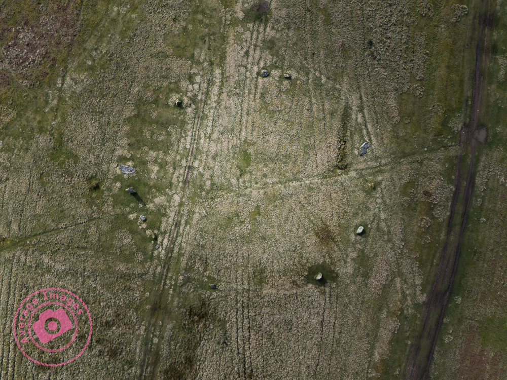
Overhead shot of the stone circle
After a good few hours walking, and a diversion due to an excessively muddy track, we headed home for impromptu washing of our boots – and the car!
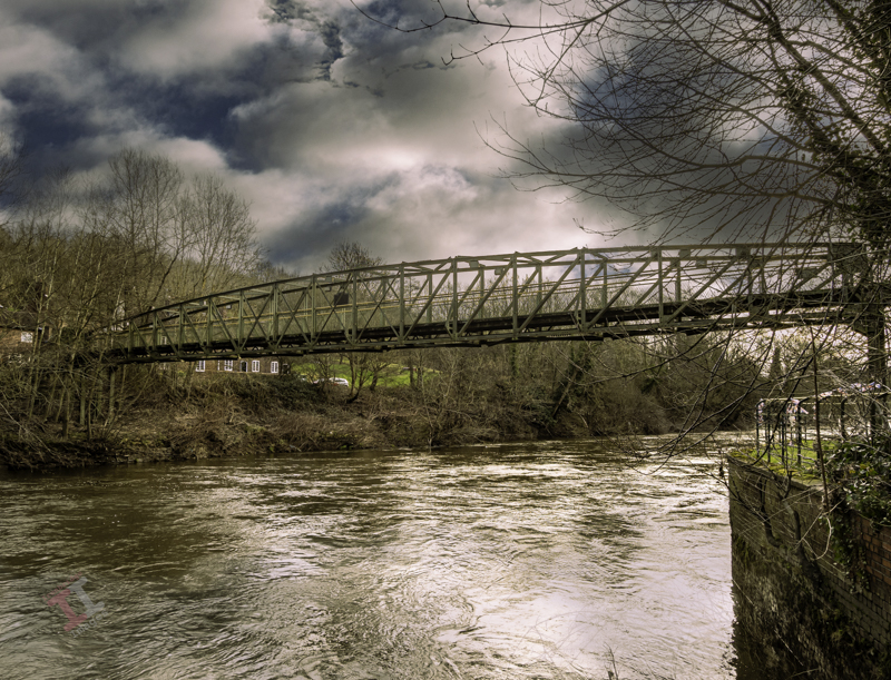
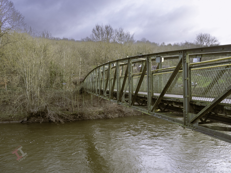
The river Severn obviously causes a bit of a disruption to free travel, and so crossing it is of interest to many. These crossing points generally choose themselves; points in the river with a flat riverbed, leading to a calmer current of water where ferries can be positioned, and/or those that are narrower, which suit a bridge.
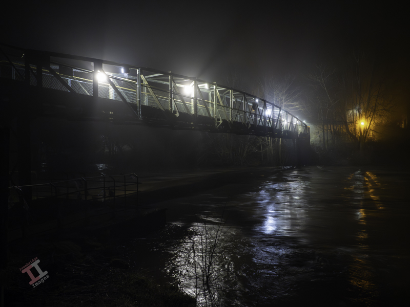
The memorial footbridge at Jackfield
One such area is at a point between Jackfield and Coalport, immediately adjacent to the Hay incline plane. Initially, a ferry provided transport for people crossing from one side to the other, which was useful with industries expanding in the area, particularly John Rose & Company, who had closed their china works in Caughley and Broseley and relocated to Coalport – but leaving the workers now having to cross the river to attend their place of work.
These ferries were usually run by owner/operators with little regulation and so accidents were quite common. On a foggy evening of 23rd October 1799, the ferry set off from Coalport towards Jackfield in the dark. Halfway across the river it capsized and, of the 43 people on board, 28 died, including women and children who had just finished their shift in the china works. There are several theories about what happened on that day to cause the ferry to sink, but the true reason remains unknown.
The river can be an unforgiving place – particularly at night.
Despite this tragedy, the ferry continued to operate in the same area and, 100 years later, claimed another life when the ferryman, John Harrison, fell overboard in a swollen January river, and was swept to his doom. He was 72 years old and still happy to work, but had slipped whilst lighting a lantern after a long day on the ferry.
Sir, The letter that appeared in your last weeks issue re the dangerous ferry at Coalport only serves to show the great necessity there is for a footbridge across the Severn at some convenient point. Unfortunately, it is not the landings that are dangerous, but the ferry-boats themselves, especially in flood time and it is fortunate that there are not more accidents than there are.
R.F. Ayre, Mayor of Wenlock. 9th February 1907
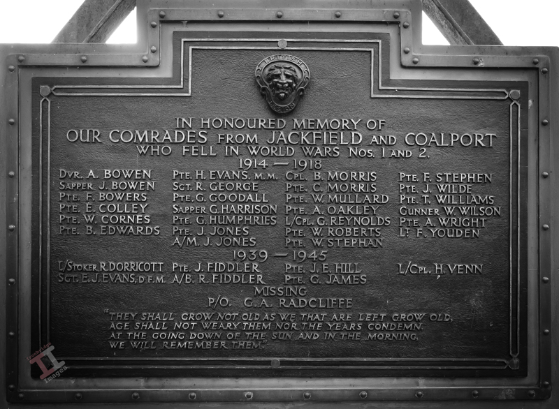
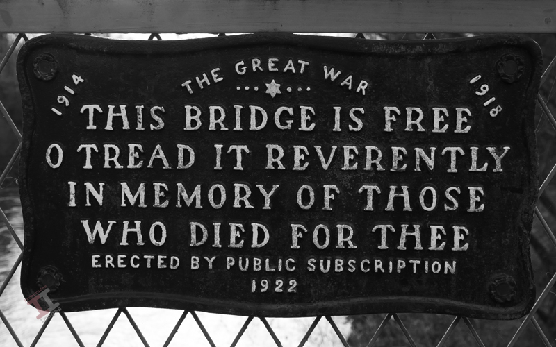
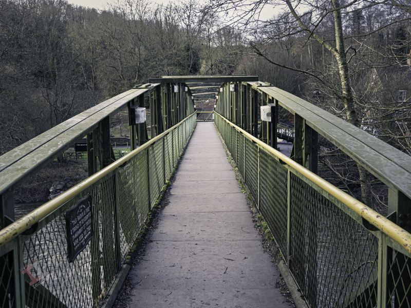
It is perhaps due to this latter tragedy that thoughts of a footbridge were mooted and, in 1922, one was built from public subscription to commemorate the 26 servicemen from the villages of Jackfield and Coalport who lost their lives in the Great War (the First World War).
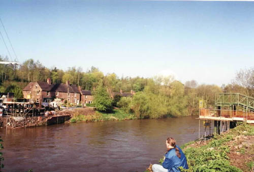
The bridge was known locally as the ‘shaky bridge’, for the obvious reason that you could feel it physically ‘bouncing’ if you walked across it with heavy feet. The bridge had a ramp at the Coalport side and a steep set of steps on the Jackfield side.
The original bridge – photograph taken by me in 1999
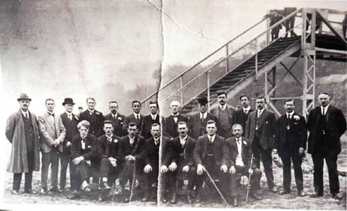
I was loaned this photograph taken of the committee shortly after the bridge was built.
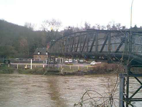
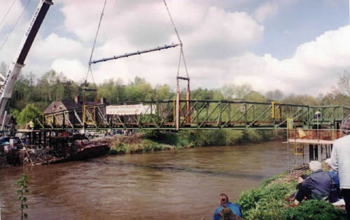
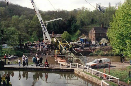
Eventually it got to a point that it was judged dangerous and so, in year 2000, it was replaced.
The replacement bridge was swung into position on Friday 28th April 2000 – and I was there to capture these shots. It was formally opened on 15th July by Lord & Lady Forester.
The replacement bridge is a tasteful improvement of the original, with gentler steps on either side, although it still bounces a bit when those of a larger disposition walk across it.
The ferry and bridge may have benefited workers at the Coalport china works in the early days, but in 1883, a large employer opened up on the Jackfield side, and so workers were now crossing in the opposite direction as well. More of that in the next Secret Ironbridge blog post.